Bessèges geodata
Bessèges (Occitanie) is a populated place; located in France in Europe/Paris (GMT+2) time zone. With population of 3,406 people, there are 2857 cities with bigger population in this country. Compared to other cities in France, 84.9% of cities are located further ↑North; 68.8% of cities are located further ←West and 61.3% of cities have lower elevation than Bessèges. Note1
Administrative division(s):
- Level 1: Occitanie
- Level 2: Gard
- Level 3: Arrondissement d’Alès
- Level 4: Bessèges


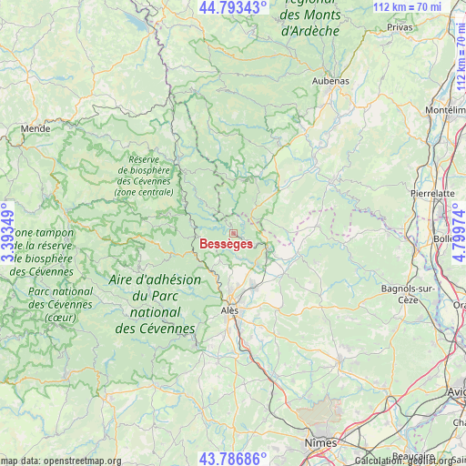
Bessèges GPS coordinates[2]
44° 17' 32.28" North, 4° 5' 47.796" East
| Map corner | latitude | longitude |
|---|---|---|
| Upper-left | 44.79343°, | 3.39349° |
| Center: | 44.2923°, | 4.09661° |
| Lower-right: | 43.78686°, | 4.79974° |
| Map W x H: | 111.9×111.9 km | = 69.5×69.5mi |
| max Lat: | 51.07786° ⇑84.9% North |
| Bessèges: | 44.2923° |
| min Lat: | ⇓15.1% South 41.3874° |
| min Long | Bessèges | max Long |
| -5.08615° | 4.09661° | 9.52242° |
| W 68.8%⇐ | ⇒31.2% E |
Elevation
Elevation of Bessèges is 176 m = 577 ft, and this is 17.7 m = 58 ft below average elevation for this country.
| Max E: |
2333 m = 7654 ft | 38.7% |
| Avg. | 193.7 m = 635 ft | |
| Bessèges | 176 m = 577 ft | |
Min E: |
-1 m = -3 ft | 61.3% |
See also: France elevation on elevation.city.
Geographical zone
Bessèges is located in North temperate zone (between Tropic of Cancer and the Arctic Circle). Distance of this Northern Tropic circle is 2318.9 km =1440.9 mi to South.| Distance of | km | miles | from Bessèges |
|---|---|---|---|
| North Pole | 5082.2 | 3157.9 | to North |
| Arctic Circle | 2476.3 | 1538.7 | to North |
| Tropic Cancer | 2318.9 | 1440.9 | to South |
| Equator | 4924.8 | 3060.1 | to South |


Nearby cities:
15 places around Bessèges: (largest is in red/bold)
• Banne
9.5 km =5.9 mi,  29°
29°
• Chamborigaud
10.1 km =6.3 mi,  278°
278°
• Gagnières
3 km =1.9 mi,  58°
58°
• Laval-Pradel
9.8 km =6.1 mi,  194°
194°
• Le Martinet
4.7 km =2.9 mi, 187°
• Les Mages
9.2 km =5.7 mi,  140°
140°
• Les Salles-du-Gardon
10.5 km =6.5 mi,  206°
206°
• Meyrannes
6.2 km =3.9 mi,  112°
112°
• Molières-sur-Cèze
6.1 km =3.8 mi,  126°
126°
• Robiac-Rochessadoule
4.1 km =2.5 mi, 134°
• Saint-Ambroix
8.9 km =5.5 mi, 114°
• Saint-André-de-Cruzières
9.9 km =6.2 mi,  75°
75°
• Saint-Florent-sur-Auzonnet
5.9 km =3.7 mi,  167°
167°
• Saint-Jean-de-Valériscle
7.9 km =4.9 mi,  149°
149°
• Saint-Paul-le-Jeune
7 km =4.3 mi,  40°
40°
Sources, notices
• [Note1] Compared only with cities in France existing in our database
• [Src1] Map data: © OpenStreetMap contributors (CC-BY-SA)
• [Src2] Other city data from geonames.org with taken over terms of usage.
• [Src3] Geographical zone / Annual Mean Temperature by Robert A. Rohde @ Wikipedia
