Gagnières geodata
Gagnières (Occitanie) is a populated place; located in France in Europe/Paris (GMT+2) time zone. With population of 997 people, there are 8849 cities with bigger population in this country. Compared to other cities in France, 84.8% of cities are located further ↑North; 69.1% of cities are located further ←West and 62.9% of cities have lower elevation than Gagnières. Note1
Administrative division(s):
- Level 1: Occitanie
- Level 2: Gard
- Level 3: Arrondissement d’Alès
- Level 4: Gagnières


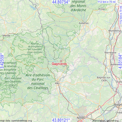
Gagnières GPS coordinates[2]
44° 18' 23.508" North, 4° 7' 43.356" East
| Map corner | latitude | longitude |
|---|---|---|
| Upper-left | 44.80754°, | 3.42559° |
| Center: | 44.30653°, | 4.12871° |
| Lower-right: | 43.80121°, | 4.83184° |
| Map W x H: | 111.9×111.9 km | = 69.5×69.5mi |
| max Lat: | 51.07786° ⇑84.8% North |
| Gagnières: | 44.30653° |
| min Lat: | ⇓15.2% South 41.3874° |
| min Long | Gagnières | max Long |
| -5.08615° | 4.12871° | 9.52242° |
| W 69.1%⇐ | ⇒30.9% E |
Elevation
Elevation of Gagnières is 184 m = 604 ft, and this is 9.7 m = 32 ft below average elevation for this country.
| Max E: |
2333 m = 7654 ft | 37.1% |
| Avg. | 193.7 m = 635 ft | |
| Gagnières | 184 m = 604 ft | |
Min E: |
-1 m = -3 ft | 62.9% |
See also: France elevation on elevation.city.
Geographical zone
Gagnières is located in North temperate zone (between Tropic of Cancer and the Arctic Circle). Distance of this Northern Tropic circle is 2320.5 km =1441.9 mi to South.| Distance of | km | miles | from Gagnières |
|---|---|---|---|
| North Pole | 5080.6 | 3156.9 | to North |
| Arctic Circle | 2474.7 | 1537.7 | to North |
| Tropic Cancer | 2320.5 | 1441.9 | to South |
| Equator | 4926.4 | 3061.1 | to South |


Nearby cities:
15 places around Gagnières: (largest is in red/bold)
• Banne
7 km =4.3 mi,  17°
17°
• Berrias-et-Casteljau
8.8 km =5.5 mi,  40°
40°
• Bessèges
3 km =1.9 mi,  238°
238°
• Le Martinet
7 km =4.3 mi,  206°
206°
• Les Mages
9.3 km =5.8 mi,  159°
159°
• Meyrannes
5 km =3.1 mi,  141°
141°
• Molières-sur-Cèze
5.7 km =3.5 mi, 155°
• Robiac-Rochessadoule
4.4 km =2.7 mi,  175°
175°
• Saint-Ambroix
7.7 km =4.8 mi,  133°
133°
• Saint-André-de-Cruzières
7 km =4.3 mi,  82°
82°
• Saint-Florent-sur-Auzonnet
7.5 km =4.7 mi,  189°
189°
• Saint-Jean-de-Valériscle
8.6 km =5.3 mi,  170°
170°
• Saint-Paul-le-Jeune
4.2 km =2.6 mi,  27°
27°
• Saint-Sauveur-de-Cruzières
10 km =6.2 mi,  94°
94°
• Saint-Victor-de-Malcap
9.6 km =6 mi, 129°
Sources, notices
• [Note1] Compared only with cities in France existing in our database
• [Src1] Map data: © OpenStreetMap contributors (CC-BY-SA)
• [Src2] Other city data from geonames.org with taken over terms of usage.
• [Src3] Geographical zone / Annual Mean Temperature by Robert A. Rohde @ Wikipedia
