Maurens geodata
Maurens (Nouvelle-Aquitaine) is a populated place; located in France in Europe/Paris (GMT+2) time zone. With population of 946 people, there are 9233 cities with bigger population in this country. Compared to other cities in France, 80.2% of cities are located further ↑North; 73.5% of cities are located further →East and 53.8% of cities have higher elevation than Maurens. Note1
Administrative division(s):
- Level 1: Nouvelle-Aquitaine
- Level 2: Dordogne
- Level 3: Arrondissement de Périgueux
- Level 4: Eyraud-Crempse-Maurens


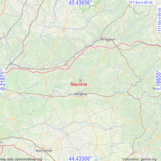
Maurens GPS coordinates[2]
44° 56' 5.892" North, 0° 29' 0.312" East
| Map corner | latitude | longitude |
|---|---|---|
| Upper-left | 45.43056°, | -0.21971° |
| Center: | 44.93497°, | 0.48342° |
| Lower-right: | 44.43506°, | 1.18655° |
| Map W x H: | 110.7×110.7 km | = 68.8×68.8mi |
| max Lat: | 51.07786° ⇑80.2% North |
| Maurens: | 44.93497° |
| min Lat: | ⇓19.8% South 41.3874° |
| min Long | Maurens | max Long |
| -5.08615° | 0.48342° | 9.52242° |
| W 26.5%⇐ | ⇒73.5% E |
Elevation
Elevation of Maurens is 120 m = 394 ft, and this is 73.7 m = 242 ft below average elevation for this country.
| Max E: |
2333 m = 7654 ft | 53.8% |
| Avg. | 193.7 m = 635 ft | |
| Maurens | 120 m = 394 ft | |
Min E: |
-1 m = -3 ft | 46.2% |
See also: France elevation on elevation.city.
Geographical zone
Maurens is located in North temperate zone (between Tropic of Cancer and the Arctic Circle). Distance of this Northern Tropic circle is 2390.4 km =1485.3 mi to South.| Distance of | km | miles | from Maurens |
|---|---|---|---|
| North Pole | 5010.8 | 3113.6 | to North |
| Arctic Circle | 2404.9 | 1494.3 | to North |
| Tropic Cancer | 2390.4 | 1485.3 | to South |
| Equator | 4996.3 | 3104.6 | to South |


Nearby cities:
15 places around Maurens: (largest is in red/bold)
• Bergerac
9.3 km =5.8 mi,  180°
180°
• Cours-de-Pile
12.1 km =7.5 mi,  155°
155°
• Creysse
11 km =6.8 mi,  143°
143°
• Ginestet
5.1 km =3.2 mi,  236°
236°
• La Force
11.2 km =7 mi,  229°
229°
• Lamonzie-Montastruc
9.7 km =6 mi,  116°
116°
• Lamonzie-Saint-Martin
12.2 km =7.6 mi,  216°
216°
• Lembras
6.6 km =4.1 mi,  148°
148°
• Mouleydier
12.6 km =7.8 mi,  134°
134°
• Prigonrieux
11 km =6.8 mi, 215°
• Queyssac
5.8 km =3.6 mi, 120°
• Saint-Laurent-des-Vignes
13.4 km =8.3 mi,  189°
189°
• Saint-Sauveur
11 km =6.8 mi, 132°
• Sourzac
14.5 km =9 mi,  331°
331°
• Villamblard
10.6 km =6.6 mi,  24°
24°
Sources, notices
• [Note1] Compared only with cities in France existing in our database
• [Src1] Map data: © OpenStreetMap contributors (CC-BY-SA)
• [Src2] Other city data from geonames.org with taken over terms of usage.
• [Src3] Geographical zone / Annual Mean Temperature by Robert A. Rohde @ Wikipedia
