Bény geodata
Bény (Auvergne-Rhône-Alpes) is a populated place; located in France in Europe/Paris (GMT+2) time zone. With population of 677 people, there are 12108 cities with bigger population in this country. Compared to other cities in France, 62% of cities are located further ↑North; 80.4% of cities are located further ←West and 71.2% of cities have lower elevation than Bény. Note1
Administrative division(s):
- Level 1: Auvergne-Rhône-Alpes
- Level 2: Département de l'Ain
- Level 3: Arrondissement de Bourg-en-Bresse
- Level 4: Bény


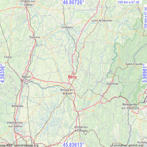
Bény GPS coordinates[2]
46° 19' 25.86" North, 5° 17' 12.084" East
| Map corner | latitude | longitude |
|---|---|---|
| Upper-left | 46.80726°, | 4.58356° |
| Center: | 46.32385°, | 5.28669° |
| Lower-right: | 45.83613°, | 5.98981° |
| Map W x H: | 108×108 km | = 67.1×67.1mi |
| max Lat: | 51.07786° ⇑62% North |
| Bény: | 46.32385° |
| min Lat: | ⇓38% South 41.3874° |
| min Long | Bény | max Long |
| -5.08615° | 5.28669° | 9.52242° |
| W 80.4%⇐ | ⇒19.6% E |
Elevation
Elevation of Bény is 225 m = 738 ft, and this is 31.3 m = 103 ft above average elevation for this country.
| Max E: |
2333 m = 7654 ft | 28.8% |
| Bény | 225 m 738 ft | |
| Avg. | 193.7 m = 635 ft | |
Min E: |
-1 m = -3 ft | 71.2% |
See also: France elevation on elevation.city.
Geographical zone
Bény is located in North temperate zone (between Tropic of Cancer and the Arctic Circle). Distance of this North polar circle is 2250.4 km =1398.3 mi to North.| Distance of | km | miles | from Bény |
|---|---|---|---|
| North Pole | 4856.3 | 3017.6 | to North |
| Arctic Circle | 2250.4 | 1398.3 | to North |
| Tropic Cancer | 2544.8 | 1581.3 | to South |
| Equator | 5150.7 | 3200.5 | to South |


Nearby cities:
15 places around Bény: (largest is in red/bold)
• Attignat
10.5 km =6.5 mi,  246°
246°
• Beaupont
9.8 km =6.1 mi,  348°
348°
• Champagne
10.3 km =6.4 mi,  209°
209°
• Coligny
7.9 km =4.9 mi,  34°
34°
• Cras-sur-Reyssouze
9 km =5.6 mi,  258°
258°
• Cuisiat
8.2 km =5.1 mi,  108°
108°
• Foissiat
10.1 km =6.3 mi,  301°
301°
• Malafretaz
11.1 km =6.9 mi,  269°
269°
• Marboz
3.1 km =1.9 mi,  313°
313°
• Meillonnas
10.2 km =6.3 mi,  151°
151°
• Saint-Étienne-du-Bois
3.8 km =2.4 mi,  170°
170°
• Treffort-Cuisiat
8.8 km =5.5 mi,  135°
135°
• Villemotier
3.7 km =2.3 mi,  46°
46°
• Viriat
9.4 km =5.8 mi,  215°
215°
• Étrez
7.8 km =4.8 mi,  278°
278°
Sources, notices
• [Note1] Compared only with cities in France existing in our database
• [Src1] Map data: © OpenStreetMap contributors (CC-BY-SA)
• [Src2] Other city data from geonames.org with taken over terms of usage.
• [Src3] Geographical zone / Annual Mean Temperature by Robert A. Rohde @ Wikipedia
