Beaupont geodata
Beaupont (Auvergne-Rhône-Alpes) is a populated place; located in France in Europe/Paris (GMT+2) time zone. With population of 536 people, there are 14480 cities with bigger population in this country. Compared to other cities in France, 60.9% of cities are located further ↑North; 80.3% of cities are located further ←West and 69.4% of cities have lower elevation than Beaupont. Note1
Administrative division(s):
- Level 1: Auvergne-Rhône-Alpes
- Level 2: Département de l'Ain
- Level 3: Arrondissement de Bourg-en-Bresse
- Level 4: Beaupont


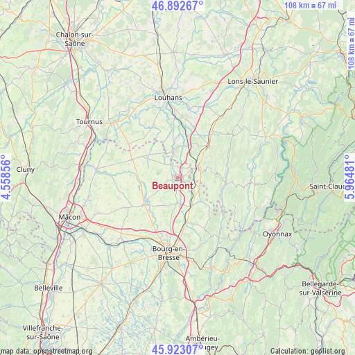
Beaupont GPS coordinates[2]
46° 24' 36.072" North, 5° 15' 42.084" East
| Map corner | latitude | longitude |
|---|---|---|
| Upper-left | 46.89267°, | 4.55856° |
| Center: | 46.41002°, | 5.26169° |
| Lower-right: | 45.92307°, | 5.96481° |
| Map W x H: | 107.8×107.8 km | = 67×67mi |
| max Lat: | 51.07786° ⇑60.9% North |
| Beaupont: | 46.41002° |
| min Lat: | ⇓39.1% South 41.3874° |
| min Long | Beaupont | max Long |
| -5.08615° | 5.26169° | 9.52242° |
| W 80.3%⇐ | ⇒19.7% E |
Elevation
Elevation of Beaupont is 216 m = 709 ft, and this is 22.3 m = 73 ft above average elevation for this country.
| Max E: |
2333 m = 7654 ft | 30.6% |
| Beaupont | 216 m 709 ft | |
| Avg. | 193.7 m = 635 ft | |
Min E: |
-1 m = -3 ft | 69.4% |
See also: France elevation on elevation.city.
Geographical zone
Beaupont is located in North temperate zone (between Tropic of Cancer and the Arctic Circle). Distance of this North polar circle is 2240.9 km =1392.4 mi to North.| Distance of | km | miles | from Beaupont |
|---|---|---|---|
| North Pole | 4846.8 | 3011.7 | to North |
| Arctic Circle | 2240.9 | 1392.4 | to North |
| Tropic Cancer | 2554.4 | 1587.2 | to South |
| Equator | 5160.3 | 3206.5 | to South |


Nearby cities:
15 places around Beaupont: (largest is in red/bold)
• Bény
9.8 km =6.1 mi,  168°
168°
• Coligny
7.1 km =4.4 mi,  115°
115°
• Cormoz
4.9 km =3 mi,  331°
331°
• Cras-sur-Reyssouze
13.3 km =8.3 mi,  211°
211°
• Dommartin-lès-Cuiseaux
10.3 km =6.4 mi,  16°
16°
• Foissiat
7.9 km =4.9 mi,  237°
237°
• Jayat
11.8 km =7.3 mi,  247°
247°
• Lescheroux
9 km =5.6 mi,  266°
266°
• Marboz
7.5 km =4.7 mi,  182°
182°
• Saint-Amour
7 km =4.3 mi,  65°
65°
• Saint-Julien-sur-Reyssouze
11.7 km =7.3 mi, 266°
• Saint-Nizier-le-Bouchoux
10.2 km =6.3 mi,  303°
303°
• Varennes-Saint-Sauveur
8.2 km =5.1 mi,  350°
350°
• Villemotier
8.4 km =5.2 mi,  147°
147°
• Étrez
10.2 km =6.3 mi, 214°
Sources, notices
• [Note1] Compared only with cities in France existing in our database
• [Src1] Map data: © OpenStreetMap contributors (CC-BY-SA)
• [Src2] Other city data from geonames.org with taken over terms of usage.
• [Src3] Geographical zone / Annual Mean Temperature by Robert A. Rohde @ Wikipedia
