Benney geodata
Benney (Grand Est) is a populated place; located in France in Europe/Paris (GMT+2) time zone. With population of 530 people, there are 14611 cities with bigger population in this country. Compared to other cities in France, 68.6% of cities are located further ↓South; 89.5% of cities are located further ←West and 80.1% of cities have lower elevation than Benney. Note1
Administrative division(s):
- Level 1: Grand Est
- Level 2: Meurthe-et-Moselle
- Level 3: Arrondissement de Nancy
- Level 4: Benney


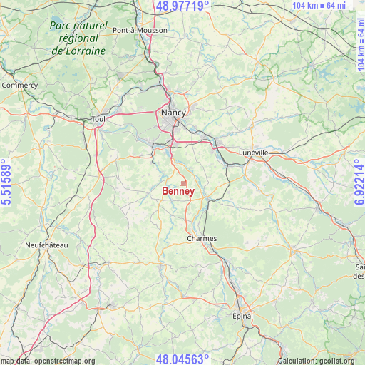
Benney GPS coordinates[2]
48° 30' 48.78" North, 6° 13' 8.436" East
| Map corner | latitude | longitude |
|---|---|---|
| Upper-left | 48.97719°, | 5.51589° |
| Center: | 48.51355°, | 6.21901° |
| Lower-right: | 48.04563°, | 6.92214° |
| Map W x H: | 103.6×103.6 km | = 64.4×64.4mi |
| max Lat: | 51.07786° ⇑31.4% North |
| Benney: | 48.51355° |
| min Lat: | ⇓68.6% South 41.3874° |
| min Long | Benney | max Long |
| -5.08615° | 6.21901° | 9.52242° |
| W 89.5%⇐ | ⇒10.5% E |
Elevation
Elevation of Benney is 291 m = 955 ft, and this is 97.3 m = 319 ft above average elevation for this country.
| Max E: |
2333 m = 7654 ft | 19.9% |
| Benney | 291 m 955 ft | |
| Avg. | 193.7 m = 635 ft | |
Min E: |
-1 m = -3 ft | 80.1% |
See also: France elevation on elevation.city.
Geographical zone
Benney is located in North temperate zone (between Tropic of Cancer and the Arctic Circle). Distance of this North polar circle is 2007 km =1247.1 mi to North.| Distance of | km | miles | from Benney |
|---|---|---|---|
| North Pole | 4612.9 | 2866.3 | to North |
| Arctic Circle | 2007 | 1247.1 | to North |
| Tropic Cancer | 2788.3 | 1732.6 | to South |
| Equator | 5394.2 | 3351.8 | to South |


Nearby cities:
15 places around Benney: (largest is in red/bold)
• Bainville-sur-Madon
12.2 km =7.6 mi,  312°
312°
• Bayon
8.4 km =5.2 mi,  121°
121°
• Ceintrey
4.3 km =2.7 mi,  286°
286°
• Flavigny-sur-Moselle
6.2 km =3.9 mi,  338°
338°
• Frolois
8.9 km =5.5 mi, 309°
• Méréville
10 km =6.2 mi,  329°
329°
• Pulligny
6.2 km =3.9 mi,  297°
297°
• Richardménil
9.6 km =6 mi, 337°
• Rosières-aux-Salines
12.1 km =7.5 mi,  43°
43°
• Roville-devant-Bayon
7.4 km =4.6 mi,  134°
134°
• Tantonville
7.7 km =4.8 mi,  230°
230°
• Tonnoy
4.9 km =3 mi,  29°
29°
• Ville-en-Vermois
11.5 km =7.1 mi,  12°
12°
• Vézelise
10.1 km =6.3 mi,  253°
253°
• Xeuilley
10.7 km =6.6 mi, 303°
Sources, notices
• [Note1] Compared only with cities in France existing in our database
• [Src1] Map data: © OpenStreetMap contributors (CC-BY-SA)
• [Src2] Other city data from geonames.org with taken over terms of usage.
• [Src3] Geographical zone / Annual Mean Temperature by Robert A. Rohde @ Wikipedia
