Tonnoy geodata
Tonnoy (Grand Est) is a populated place; located in France in Europe/Paris (GMT+2) time zone. With population of 683 people, there are 12036 cities with bigger population in this country. Compared to other cities in France, 69.6% of cities are located further ↓South; 89.8% of cities are located further ←West and 79.5% of cities have lower elevation than Tonnoy. Note1
Administrative division(s):
- Level 1: Grand Est
- Level 2: Meurthe-et-Moselle
- Level 3: Arrondissement de Nancy
- Level 4: Tonnoy


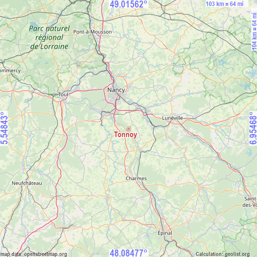
Tonnoy GPS coordinates[2]
48° 33' 8.424" North, 6° 15' 5.616" East
| Map corner | latitude | longitude |
|---|---|---|
| Upper-left | 49.01562°, | 5.54843° |
| Center: | 48.55234°, | 6.25156° |
| Lower-right: | 48.08477°, | 6.95468° |
| Map W x H: | 103.5×103.5 km | = 64.3×64.3mi |
| max Lat: | 51.07786° ⇑30.4% North |
| Tonnoy: | 48.55234° |
| min Lat: | ⇓69.6% South 41.3874° |
| min Long | Tonnoy | max Long |
| -5.08615° | 6.25156° | 9.52242° |
| W 89.8%⇐ | ⇒10.2% E |
Elevation
Elevation of Tonnoy is 285 m = 935 ft, and this is 91.3 m = 300 ft above average elevation for this country.
| Max E: |
2333 m = 7654 ft | 20.5% |
| Tonnoy | 285 m 935 ft | |
| Avg. | 193.7 m = 635 ft | |
Min E: |
-1 m = -3 ft | 79.5% |
See also: France elevation on elevation.city.
Geographical zone
Tonnoy is located in North temperate zone (between Tropic of Cancer and the Arctic Circle). Distance of this North polar circle is 2002.7 km =1244.4 mi to North.| Distance of | km | miles | from Tonnoy |
|---|---|---|---|
| North Pole | 4608.5 | 2863.6 | to North |
| Arctic Circle | 2002.7 | 1244.4 | to North |
| Tropic Cancer | 2792.6 | 1735.2 | to South |
| Equator | 5398.5 | 3354.5 | to South |


Nearby cities:
15 places around Tonnoy: (largest is in red/bold)
• Bayon
9.9 km =6.2 mi,  151°
151°
• Benney
4.9 km =3 mi,  209°
209°
• Ceintrey
7.2 km =4.5 mi,  244°
244°
• Damelevières
9.8 km =6.1 mi,  85°
85°
• Flavigny-sur-Moselle
4.9 km =3 mi,  287°
287°
• Fléville-devant-Nancy
8.8 km =5.5 mi,  336°
336°
• Frolois
9.4 km =5.8 mi,  278°
278°
• Ludres
9.8 km =6.1 mi,  320°
320°
• Méréville
8.6 km =5.3 mi,  300°
300°
• Pulligny
8 km =5 mi,  259°
259°
• Richardménil
7.6 km =4.7 mi,  306°
306°
• Rosières-aux-Salines
7.4 km =4.6 mi,  52°
52°
• Roville-devant-Bayon
9.9 km =6.2 mi,  162°
162°
• Saint-Nicolas-de-Port
9.1 km =5.7 mi,  21°
21°
• Ville-en-Vermois
6.9 km =4.3 mi,  1°
1°
Sources, notices
• [Note1] Compared only with cities in France existing in our database
• [Src1] Map data: © OpenStreetMap contributors (CC-BY-SA)
• [Src2] Other city data from geonames.org with taken over terms of usage.
• [Src3] Geographical zone / Annual Mean Temperature by Robert A. Rohde @ Wikipedia
