Belleville-sur-Vie geodata
Belleville-sur-Vie (Pays de la Loire) is a populated place; located in France in Europe/Paris (GMT+2) time zone. With population of 3,200 people, there are 3048 cities with bigger population in this country. Compared to other cities in France, 57.4% of cities are located further ↑North; 91.7% of cities are located further →East and 73.1% of cities have higher elevation than Belleville-sur-Vie. Note1
Administrative division(s):
- Level 1: Pays de la Loire
- Level 2: Département de la Vendée
- Level 3: Arrondissement de La Roche-sur-Yon
- Level 4: Bellevigny


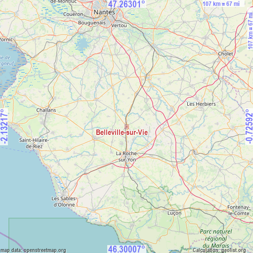
Belleville-sur-Vie GPS coordinates[2]
46° 47' 1.284" North, 1° 25' 44.58" West
| Map corner | latitude | longitude |
|---|---|---|
| Upper-left | 47.26301°, | -2.13217° |
| Center: | 46.78369°, | -1.42905° |
| Lower-right: | 46.30007°, | -0.72592° |
| Map W x H: | 107.1×107.1 km | = 66.5×66.5mi |
| max Lat: | 51.07786° ⇑57.4% North |
| Belleville-sur-Vie: | 46.78369° |
| min Lat: | ⇓42.6% South 41.3874° |
| min Long | Belleville-sur- | max Long |
| -5.08615° | -1.42905° | 9.52242° |
| W 8.3%⇐ | ⇒91.7% E |
Elevation
Elevation of Belleville-sur-Vie is 71 m = 233 ft, and this is 122.7 m = 403 ft below average elevation for this country.
| Max E: |
2333 m = 7654 ft | 73.1% |
| Avg. | 193.7 m = 635 ft | |
| Belleville-sur-Vie | 71 m = 233 ft | |
Min E: |
-1 m = -3 ft | 26.9% |
See also: France elevation on elevation.city.
Geographical zone
Belleville-sur-Vie is located in North temperate zone (between Tropic of Cancer and the Arctic Circle). Distance of this North polar circle is 2199.3 km =1366.6 mi to North.| Distance of | km | miles | from Belleville-sur-Vie |
|---|---|---|---|
| North Pole | 4805.2 | 2985.8 | to North |
| Arctic Circle | 2199.3 | 1366.6 | to North |
| Tropic Cancer | 2595.9 | 1613 | to South |
| Equator | 5201.9 | 3232.3 | to South |


Nearby cities:
15 places around Belleville-sur-Vie: (largest is in red/bold)
• Boulogne
8.4 km =5.2 mi,  82°
82°
• Chauché
13 km =8.1 mi,  66°
66°
• Dompierre-sur-Yon
6.1 km =3.8 mi,  146°
146°
• La Copechagnière
9.6 km =6 mi,  41°
41°
• La Ferrière
11.7 km =7.3 mi,  131°
131°
• La Génétouze
8.7 km =5.4 mi,  230°
230°
• La Merlatière
9.9 km =6.2 mi,  99°
99°
• La Roche-sur-Yon
13 km =8.1 mi,  181°
181°
• Le Poiré-sur-Vie
6.3 km =3.9 mi,  255°
255°
• Les Lucs-sur-Boulogne
8.4 km =5.2 mi,  323°
323°
• Mouilleron-le-Captif
7.5 km =4.7 mi,  195°
195°
• Saint-Denis-la-Chevasse
7 km =4.3 mi,  51°
51°
• Saint-Sulpice-le-Verdon
12.3 km =7.6 mi,  3°
3°
• Saligny
2.7 km =1.7 mi, 2°
• Venansault
12.7 km =7.9 mi,  210°
210°
Sources, notices
• [Note1] Compared only with cities in France existing in our database
• [Src1] Map data: © OpenStreetMap contributors (CC-BY-SA)
• [Src2] Other city data from geonames.org with taken over terms of usage.
• [Src3] Geographical zone / Annual Mean Temperature by Robert A. Rohde @ Wikipedia
