La Roche-sur-Yon geodata
La Roche-sur-Yon (Pays de la Loire) is a seat of a second-order administrative division; located in France in Europe/Paris (GMT+2) time zone. With population of 59,410 people, there are 85 cities with bigger population in this country. Compared to other cities in France, 58.6% of cities are located further ↑North; 91.8% of cities are located further →East and 75.8% of cities have higher elevation than La Roche-sur-Yon. Note1
Administrative division(s):
- Level 1: Pays de la Loire
- Level 2: Département de la Vendée
- Level 3: Arrondissement de La Roche-sur-Yon
- Level 4: La Roche-sur-Yon


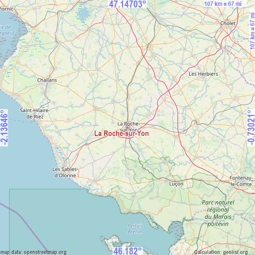
La Roche-sur-Yon GPS coordinates[2]
46° 40' 0.012" North, 1° 25' 59.988" West
| Map corner | latitude | longitude |
|---|---|---|
| Upper-left | 47.14703°, | -2.13646° |
| Center: | 46.66667°, | -1.43333° |
| Lower-right: | 46.182°, | -0.73021° |
| Map W x H: | 107.3×107.3 km | = 66.7×66.7mi |
| max Lat: | 51.07786° ⇑58.6% North |
| La Roche-sur-Yon: | 46.66667° |
| min Lat: | ⇓41.4% South 41.3874° |
| min Long | La Roche-sur-Yo | max Long |
| -5.08615° | -1.43333° | 9.52242° |
| W 8.2%⇐ | ⇒91.8% E |
Elevation
Elevation of La Roche-sur-Yon is 65 m = 213 ft, and this is 128.7 m = 422 ft below average elevation for this country.
| Max E: |
2333 m = 7654 ft | 75.8% |
| Avg. | 193.7 m = 635 ft | |
| La Roche-sur-Yon | 65 m = 213 ft | |
Min E: |
-1 m = -3 ft | 24.2% |
See also: La Roche-sur-Yon elevation on elevation.city.
Geographical zone
La Roche-sur-Yon is located in North temperate zone (between Tropic of Cancer and the Arctic Circle). Distance of this North polar circle is 2212.3 km =1374.7 mi to North.| Distance of | km | miles | from La Roche-sur-Yon |
|---|---|---|---|
| North Pole | 4818.2 | 2993.9 | to North |
| Arctic Circle | 2212.3 | 1374.7 | to North |
| Tropic Cancer | 2582.9 | 1604.9 | to South |
| Equator | 5188.8 | 3224.2 | to South |


Nearby cities:
15 places around La Roche-sur-Yon: (largest is in red/bold)
• Aubigny
8 km =5 mi,  191°
191°
• Dompierre-sur-Yon
8.8 km =5.5 mi,  24°
24°
• La Boissière-des-Landes
11.6 km =7.2 mi, 190°
• La Chaize-le-Vicomte
10.9 km =6.8 mi,  87°
87°
• La Ferrière
10.5 km =6.5 mi,  59°
59°
• La Génétouze
9.8 km =6.1 mi,  319°
319°
• Landeronde
10.4 km =6.5 mi,  264°
264°
• Le Poiré-sur-Vie
12.8 km =8 mi,  333°
333°
• Les Clouzeaux
7.2 km =4.5 mi,  234°
234°
• Mouilleron-le-Captif
6 km =3.7 mi,  344°
344°
• Nesmy
8.8 km =5.5 mi,  163°
163°
• Nieul-le-Dolent
11.8 km =7.3 mi,  208°
208°
• Saint-Florent-des-Bois
12.1 km =7.5 mi,  132°
132°
• Sainte-Flaive-des-Loups
12.7 km =7.9 mi,  242°
242°
• Venansault
6.5 km =4 mi,  288°
288°
Sources, notices
• [Note1] Compared only with cities in France existing in our database
• [Src1] Map data: © OpenStreetMap contributors (CC-BY-SA)
• [Src2] Other city data from geonames.org with taken over terms of usage.
• [Src3] Geographical zone / Annual Mean Temperature by Robert A. Rohde @ Wikipedia
