Venansault geodata
Venansault (Pays de la Loire) is a populated place; located in France in Europe/Paris (GMT+2) time zone. With population of 3,955 people, there are 2490 cities with bigger population in this country. Compared to other cities in France, 58.3% of cities are located further ↑North; 92.4% of cities are located further →East and 80.6% of cities have higher elevation than Venansault. Note1
Administrative division(s):
- Level 1: Pays de la Loire
- Level 2: Département de la Vendée
- Level 3: Arrondissement de La Roche-sur-Yon
- Level 4: Venansault


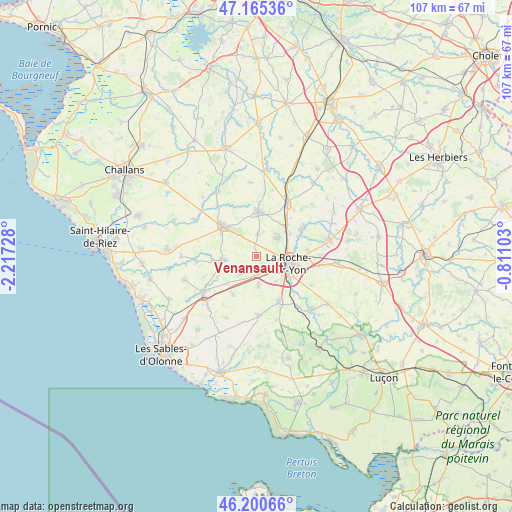
Venansault GPS coordinates[2]
46° 41' 6.576" North, 1° 30' 50.94" West
| Map corner | latitude | longitude |
|---|---|---|
| Upper-left | 47.16536°, | -2.21728° |
| Center: | 46.68516°, | -1.51415° |
| Lower-right: | 46.20066°, | -0.81103° |
| Map W x H: | 107.3×107.3 km | = 66.7×66.7mi |
| max Lat: | 51.07786° ⇑58.3% North |
| Venansault: | 46.68516° |
| min Lat: | ⇓41.7% South 41.3874° |
| min Long | Venansault | max Long |
| -5.08615° | -1.51415° | 9.52242° |
| W 7.6%⇐ | ⇒92.4% E |
Elevation
Elevation of Venansault is 53 m = 174 ft, and this is 140.7 m = 462 ft below average elevation for this country.
| Max E: |
2333 m = 7654 ft | 80.6% |
| Avg. | 193.7 m = 635 ft | |
| Venansault | 53 m = 174 ft | |
Min E: |
-1 m = -3 ft | 19.4% |
See also: France elevation on elevation.city.
Geographical zone
Venansault is located in North temperate zone (between Tropic of Cancer and the Arctic Circle). Distance of this North polar circle is 2210.3 km =1373.4 mi to North.| Distance of | km | miles | from Venansault |
|---|---|---|---|
| North Pole | 4816.2 | 2992.6 | to North |
| Arctic Circle | 2210.3 | 1373.4 | to North |
| Tropic Cancer | 2585 | 1606.2 | to South |
| Equator | 5190.9 | 3225.5 | to South |


Nearby cities:
15 places around Venansault: (largest is in red/bold)
• Aizenay
9.4 km =5.8 mi,  310°
310°
• Aubigny
10.9 km =6.8 mi,  154°
154°
• Beaulieu-sous-la-Roche
7.5 km =4.7 mi,  262°
262°
• Belleville-sur-Vie
12.7 km =7.9 mi,  30°
30°
• Dompierre-sur-Yon
11.5 km =7.1 mi,  58°
58°
• La Génétouze
5.4 km =3.4 mi,  357°
357°
• La Roche-sur-Yon
6.5 km =4 mi,  108°
108°
• Landeronde
5.2 km =3.2 mi,  233°
233°
• Le Poiré-sur-Vie
9.4 km =5.8 mi,  2°
2°
• Les Clouzeaux
6.3 km =3.9 mi,  176°
176°
• Martinet
12.8 km =8 mi,  265°
265°
• Mouilleron-le-Captif
5.9 km =3.7 mi,  50°
50°
• Nieul-le-Dolent
12.4 km =7.7 mi, 177°
• Saint-Georges-de-Pointindoux
9.4 km =5.8 mi,  241°
241°
• Sainte-Flaive-des-Loups
9.5 km =5.9 mi,  212°
212°
Sources, notices
• [Note1] Compared only with cities in France existing in our database
• [Src1] Map data: © OpenStreetMap contributors (CC-BY-SA)
• [Src2] Other city data from geonames.org with taken over terms of usage.
• [Src3] Geographical zone / Annual Mean Temperature by Robert A. Rohde @ Wikipedia
