Villié-Morgon geodata
Villié-Morgon (Auvergne-Rhône-Alpes) is a populated place; located in France in Europe/Paris (GMT+2) time zone. With population of 1,748 people, there are 5419 cities with bigger population in this country. Compared to other cities in France, 64.1% of cities are located further ↑North; 73.5% of cities are located further ←West and 79.2% of cities have lower elevation than Villié-Morgon. Note1
Administrative division(s):
- Level 1: Auvergne-Rhône-Alpes
- Level 2: Département du Rhône
- Level 3: Arrondissement de Villefranche-sur-Saône
- Level 4: Villié-Morgon


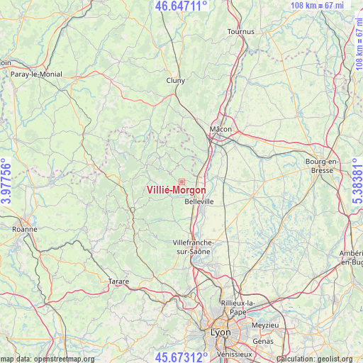
Villié-Morgon GPS coordinates[2]
46° 9' 44.172" North, 4° 40' 50.484" East
| Map corner | latitude | longitude |
|---|---|---|
| Upper-left | 46.64711°, | 3.97756° |
| Center: | 46.16227°, | 4.68069° |
| Lower-right: | 45.67312°, | 5.38381° |
| Map W x H: | 108.3×108.3 km | = 67.3×67.3mi |
| max Lat: | 51.07786° ⇑64.1% North |
| Villié-Morgon: | 46.16227° |
| min Lat: | ⇓35.9% South 41.3874° |
| min Long | Villié-Morgon | max Long |
| -5.08615° | 4.68069° | 9.52242° |
| W 73.5%⇐ | ⇒26.5% E |
Elevation
Elevation of Villié-Morgon is 282 m = 925 ft, and this is 88.3 m = 290 ft above average elevation for this country.
| Max E: |
2333 m = 7654 ft | 20.8% |
| Villié-Morgon | 282 m 925 ft | |
| Avg. | 193.7 m = 635 ft | |
Min E: |
-1 m = -3 ft | 79.2% |
See also: France elevation on elevation.city.
Geographical zone
Villié-Morgon is located in North temperate zone (between Tropic of Cancer and the Arctic Circle). Distance of this North polar circle is 2268.4 km =1409.5 mi to North.| Distance of | km | miles | from Villié-Morgon |
|---|---|---|---|
| North Pole | 4874.3 | 3028.7 | to North |
| Arctic Circle | 2268.4 | 1409.5 | to North |
| Tropic Cancer | 2526.8 | 1570.1 | to South |
| Equator | 5132.8 | 3189.4 | to South |


Nearby cities:
15 places around Villié-Morgon: (largest is in red/bold)
• Beaujeu
7.2 km =4.5 mi,  262°
262°
• Belleville
8 km =5 mi,  138°
138°
• Cercié
4.8 km =3 mi,  189°
189°
• Charentay
8.2 km =5.1 mi,  180°
180°
• Corcelles-en-Beaujolais
3.4 km =2.1 mi,  105°
105°
• Dracé
6.6 km =4.1 mi,  95°
95°
• Durette
3.5 km =2.2 mi,  211°
211°
• Fleurie
3.6 km =2.2 mi,  21°
21°
• La Chapelle-de-Guinchay
8.1 km =5 mi,  50°
50°
• Lancié
2.8 km =1.7 mi,  69°
69°
• Lantignié
4.7 km =2.9 mi,  249°
249°
• Quincié-en-Beaujolais
6.9 km =4.3 mi,  225°
225°
• Romanèche-Thorins
5.3 km =3.3 mi,  63°
63°
• Saint-Lager
5.7 km =3.5 mi, 186°
• Taponas
8 km =5 mi,  124°
124°
Sources, notices
• [Note1] Compared only with cities in France existing in our database
• [Src1] Map data: © OpenStreetMap contributors (CC-BY-SA)
• [Src2] Other city data from geonames.org with taken over terms of usage.
• [Src3] Geographical zone / Annual Mean Temperature by Robert A. Rohde @ Wikipedia
