Bellac geodata
Bellac (Nouvelle-Aquitaine) is a seat of a third-order administrative division; located in France in Europe/Paris (GMT+2) time zone. With population of 4,973 people, there are 1991 cities with bigger population in this country. Compared to other cities in France, 64.7% of cities are located further ↑North; 68.3% of cities are located further →East and 74.3% of cities have lower elevation than Bellac. Note1
Administrative division(s):
- Level 1: Nouvelle-Aquitaine
- Level 2: Haute-Vienne
- Level 3: Arrondissement de Bellac
- Level 4: Bellac


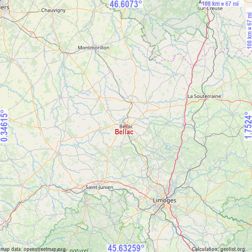
Bellac GPS coordinates[2]
46° 7' 19.56" North, 1° 2' 57.372" East
| Map corner | latitude | longitude |
|---|---|---|
| Upper-left | 46.6073°, | 0.34615° |
| Center: | 46.1221°, | 1.04927° |
| Lower-right: | 45.63259°, | 1.7524° |
| Map W x H: | 108.4×108.4 km | = 67.4×67.4mi |
| max Lat: | 51.07786° ⇑64.7% North |
| Bellac: | 46.1221° |
| min Lat: | ⇓35.3% South 41.3874° |
| min Long | Bellac | max Long |
| -5.08615° | 1.04927° | 9.52242° |
| W 31.7%⇐ | ⇒68.3% E |
Elevation
Elevation of Bellac is 244 m = 801 ft, and this is 50.3 m = 165 ft above average elevation for this country.
| Max E: |
2333 m = 7654 ft | 25.7% |
| Bellac | 244 m 801 ft | |
| Avg. | 193.7 m = 635 ft | |
Min E: |
-1 m = -3 ft | 74.3% |
See also: France elevation on elevation.city.
Geographical zone
Bellac is located in North temperate zone (between Tropic of Cancer and the Arctic Circle). Distance of this North polar circle is 2272.9 km =1412.3 mi to North.| Distance of | km | miles | from Bellac |
|---|---|---|---|
| North Pole | 4878.8 | 3031.5 | to North |
| Arctic Circle | 2272.9 | 1412.3 | to North |
| Tropic Cancer | 2522.4 | 1567.3 | to South |
| Equator | 5128.3 | 3186.6 | to South |


Nearby cities:
15 places around Bellac: (largest is in red/bold)
• Blond
8.9 km =5.5 mi,  195°
195°
• Bussière-Poitevine
16.8 km =10.4 mi,  318°
318°
• Chamboret
14.6 km =9.1 mi,  152°
152°
• Châteauponsac
17.4 km =10.8 mi,  85°
85°
• Cieux
14.5 km =9 mi,  181°
181°
• Javerdat
19.3 km =12 mi,  194°
194°
• Le Dorat
10.6 km =6.6 mi,  13°
13°
• Magnac-Laval
13.7 km =8.5 mi,  41°
41°
• Mézières-sur-Issoire
10.8 km =6.7 mi,  261°
261°
• Nantiat
15.8 km =9.8 mi,  142°
142°
• Nouic
12.2 km =7.6 mi,  235°
235°
• Peyrat-de-Bellac
2.4 km =1.5 mi,  336°
336°
• Peyrilhac
20.2 km =12.6 mi,  161°
161°
• Rancon
10.3 km =6.4 mi,  84°
84°
• Saint-Bonnet-de-Bellac
9 km =5.6 mi,  305°
305°
Sources, notices
• [Note1] Compared only with cities in France existing in our database
• [Src1] Map data: © OpenStreetMap contributors (CC-BY-SA)
• [Src2] Other city data from geonames.org with taken over terms of usage.
• [Src3] Geographical zone / Annual Mean Temperature by Robert A. Rohde @ Wikipedia
