Le Dorat geodata
Le Dorat (Nouvelle-Aquitaine) is a populated place; located in France in Europe/Paris (GMT+2) time zone. With population of 2,134 people, there are 4505 cities with bigger population in this country. Compared to other cities in France, 63.3% of cities are located further ↑North; 68% of cities are located further →East and 71% of cities have lower elevation than Le Dorat. Note1
Administrative division(s):
- Level 1: Nouvelle-Aquitaine
- Level 2: Haute-Vienne
- Level 3: Arrondissement de Bellac
- Level 4: Le Dorat


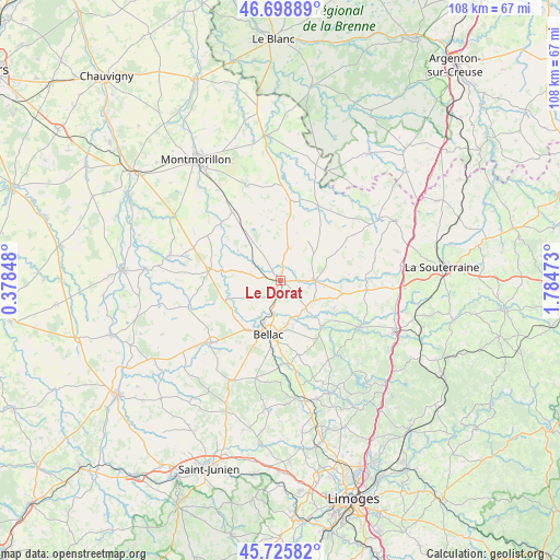
Le Dorat GPS coordinates[2]
46° 12' 52.236" North, 1° 4' 53.76" East
| Map corner | latitude | longitude |
|---|---|---|
| Upper-left | 46.69889°, | 0.37848° |
| Center: | 46.21451°, | 1.0816° |
| Lower-right: | 45.72582°, | 1.78473° |
| Map W x H: | 108.2×108.2 km | = 67.2×67.2mi |
| max Lat: | 51.07786° ⇑63.3% North |
| Le Dorat: | 46.21451° |
| min Lat: | ⇓36.7% South 41.3874° |
| min Long | Le Dorat | max Long |
| -5.08615° | 1.0816° | 9.52242° |
| W 32%⇐ | ⇒68% E |
Elevation
Elevation of Le Dorat is 224 m = 735 ft, and this is 30.3 m = 99 ft above average elevation for this country.
| Max E: |
2333 m = 7654 ft | 29% |
| Le Dorat | 224 m 735 ft | |
| Avg. | 193.7 m = 635 ft | |
Min E: |
-1 m = -3 ft | 71% |
See also: France elevation on elevation.city.
Geographical zone
Le Dorat is located in North temperate zone (between Tropic of Cancer and the Arctic Circle). Distance of this North polar circle is 2262.6 km =1405.9 mi to North.| Distance of | km | miles | from Le Dorat |
|---|---|---|---|
| North Pole | 4868.5 | 3025.1 | to North |
| Arctic Circle | 2262.6 | 1405.9 | to North |
| Tropic Cancer | 2532.7 | 1573.7 | to South |
| Equator | 5138.6 | 3193 | to South |


Nearby cities:
15 places around Le Dorat: (largest is in red/bold)
• Bellac
10.6 km =6.6 mi,  193°
193°
• Blond
19.5 km =12.1 mi, 194°
• Brigueil-le-Chantre
20.2 km =12.6 mi,  1°
1°
• Bussière-Poitevine
13.8 km =8.6 mi,  279°
279°
• Châteauponsac
17.4 km =10.8 mi,  120°
120°
• Lathus-Saint-Rémy
16.4 km =10.2 mi,  324°
324°
• Lussac-les-Églises
16.2 km =10.1 mi,  26°
26°
• Magnac-Laval
6.5 km =4 mi,  89°
89°
• Mézières-sur-Issoire
17.7 km =11 mi,  227°
227°
• Nouic
21.2 km =13.2 mi,  216°
216°
• Peyrat-de-Bellac
8.8 km =5.5 mi,  203°
203°
• Rancon
12.1 km =7.5 mi,  140°
140°
• Saint-Bonnet-de-Bellac
11.1 km =6.9 mi,  242°
242°
• Saint-Léger-Magnazeix
15.1 km =9.4 mi,  57°
57°
• Saint-Sornin-Leulac
16.7 km =10.4 mi,  95°
95°
Sources, notices
• [Note1] Compared only with cities in France existing in our database
• [Src1] Map data: © OpenStreetMap contributors (CC-BY-SA)
• [Src2] Other city data from geonames.org with taken over terms of usage.
• [Src3] Geographical zone / Annual Mean Temperature by Robert A. Rohde @ Wikipedia
