Beignon geodata
Beignon (Brittany) is a populated place; located in France in Europe/Paris (GMT+2) time zone. With population of 1,074 people, there are 8304 cities with bigger population in this country. Compared to other cities in France, 58.8% of cities are located further ↓South; 95.4% of cities are located further →East and 53.1% of cities have higher elevation than Beignon. Note1
Administrative division(s):
- Level 1: Brittany
- Level 2: Morbihan
- Level 3: Arrondissement de Vannes
- Level 4: Beignon


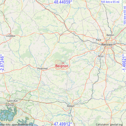
Beignon GPS coordinates[2]
47° 58' 19.2" North, 2° 10' 9.588" West
| Map corner | latitude | longitude |
|---|---|---|
| Upper-left | 48.44059°, | -2.87246° |
| Center: | 47.972°, | -2.16933° |
| Lower-right: | 47.49912°, | -1.46621° |
| Map W x H: | 104.7×104.7 km | = 65.1×65.1mi |
| max Lat: | 51.07786° ⇑41.2% North |
| Beignon: | 47.972° |
| min Lat: | ⇓58.8% South 41.3874° |
| min Long | Beignon | max Long |
| -5.08615° | -2.16933° | 9.52242° |
| W 4.6%⇐ | ⇒95.4% E |
Elevation
Elevation of Beignon is 122 m = 400 ft, and this is 71.7 m = 235 ft below average elevation for this country.
| Max E: |
2333 m = 7654 ft | 53.1% |
| Avg. | 193.7 m = 635 ft | |
| Beignon | 122 m = 400 ft | |
Min E: |
-1 m = -3 ft | 46.9% |
See also: France elevation on elevation.city.
Geographical zone
Beignon is located in North temperate zone (between Tropic of Cancer and the Arctic Circle). Distance of this North polar circle is 2067.2 km =1284.5 mi to North.| Distance of | km | miles | from Beignon |
|---|---|---|---|
| North Pole | 4673.1 | 2903.7 | to North |
| Arctic Circle | 2067.2 | 1284.5 | to North |
| Tropic Cancer | 2728.1 | 1695.2 | to South |
| Equator | 5334 | 3314.4 | to South |


Nearby cities:
15 places around Beignon: (largest is in red/bold)
• Augan
10 km =6.2 mi,  234°
234°
• Campénéac
9.3 km =5.8 mi,  259°
259°
• Comblessac
12.4 km =7.7 mi,  148°
148°
• Concoret
10.6 km =6.6 mi,  345°
345°
• Guer
8.1 km =5 mi, 154°
• Mauron
15 km =9.3 mi,  325°
325°
• Maxent
10.2 km =6.3 mi,  82°
82°
• Monteneuf
11.4 km =7.1 mi,  195°
195°
• Néant-sur-Yvel
12.7 km =7.9 mi,  291°
291°
• Paimpont
5.1 km =3.2 mi,  358°
358°
• Plélan-le-Grand
6.2 km =3.9 mi,  58°
58°
• Porcaro
7.2 km =4.5 mi, 197°
• Saint-Malo-de-Beignon
2.2 km =1.4 mi,  132°
132°
• Treffendel
14.2 km =8.8 mi, 58°
• Tréal
15.5 km =9.6 mi, 195°
Sources, notices
• [Note1] Compared only with cities in France existing in our database
• [Src1] Map data: © OpenStreetMap contributors (CC-BY-SA)
• [Src2] Other city data from geonames.org with taken over terms of usage.
• [Src3] Geographical zone / Annual Mean Temperature by Robert A. Rohde @ Wikipedia
