Plélan-le-Grand geodata
Plélan-le-Grand (Brittany) is a populated place; located in France in Europe/Paris (GMT+2) time zone. With population of 3,220 people, there are 3030 cities with bigger population in this country. Compared to other cities in France, 59.3% of cities are located further ↓South; 95.2% of cities are located further →East and 51.4% of cities have lower elevation than Plélan-le-Grand. Note1
Administrative division(s):
- Level 1: Brittany
- Level 2: Département d'Ille-et-Vilaine
- Level 3: Arrondissement de Rennes
- Level 4: Plélan-le-Grand


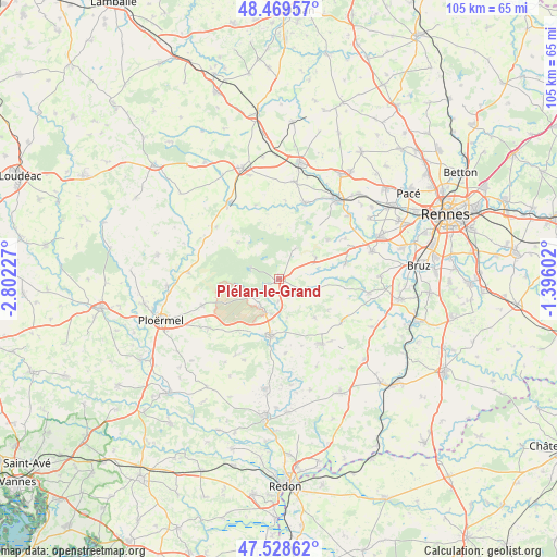
Plélan-le-Grand GPS coordinates[2]
48° 0' 4.464" North, 2° 5' 56.904" West
| Map corner | latitude | longitude |
|---|---|---|
| Upper-left | 48.46957°, | -2.80227° |
| Center: | 48.00124°, | -2.09914° |
| Lower-right: | 47.52862°, | -1.39602° |
| Map W x H: | 104.6×104.6 km | = 65×65mi |
| max Lat: | 51.07786° ⇑40.7% North |
| Plélan-le-Grand: | 48.00124° |
| min Lat: | ⇓59.3% South 41.3874° |
| min Long | Plélan-le-Gran | max Long |
| -5.08615° | -2.09914° | 9.52242° |
| W 4.8%⇐ | ⇒95.2% E |
Elevation
Elevation of Plélan-le-Grand is 137 m = 449 ft, and this is 56.7 m = 186 ft below average elevation for this country.
| Max E: |
2333 m = 7654 ft | 48.6% |
| Avg. | 193.7 m = 635 ft | |
| Plélan-le-Grand | 137 m = 449 ft | |
Min E: |
-1 m = -3 ft | 51.4% |
See also: France elevation on elevation.city.
Geographical zone
Plélan-le-Grand is located in North temperate zone (between Tropic of Cancer and the Arctic Circle). Distance of this North polar circle is 2063.9 km =1282.4 mi to North.| Distance of | km | miles | from Plélan-le-Grand |
|---|---|---|---|
| North Pole | 4669.8 | 2901.7 | to North |
| Arctic Circle | 2063.9 | 1282.4 | to North |
| Tropic Cancer | 2731.3 | 1697.2 | to South |
| Equator | 5337.2 | 3316.4 | to South |


Nearby cities:
15 places around Plélan-le-Grand: (largest is in red/bold)
• Baulon
12.6 km =7.8 mi,  97°
97°
• Beignon
6.2 km =3.9 mi,  238°
238°
• Comblessac
13.9 km =8.6 mi,  175°
175°
• Concoret
10.5 km =6.5 mi,  311°
311°
• Guer
10.7 km =6.6 mi,  189°
189°
• La Chapelle-Bouexic
14.3 km =8.9 mi,  124°
124°
• Maure-de-Bretagne
14.5 km =9 mi,  146°
146°
• Maxent
5.3 km =3.3 mi,  112°
112°
• Monterfil
11.6 km =7.2 mi,  50°
50°
• Muel
14.6 km =9.1 mi,  342°
342°
• Paimpont
5.7 km =3.5 mi,  289°
289°
• Porcaro
12.6 km =7.8 mi,  216°
216°
• Saint-Malo-de-Beignon
6 km =3.7 mi, 217°
• Saint-Thurial
12.8 km =8 mi,  75°
75°
• Treffendel
8.1 km =5 mi,  58°
58°
Sources, notices
• [Note1] Compared only with cities in France existing in our database
• [Src1] Map data: © OpenStreetMap contributors (CC-BY-SA)
• [Src2] Other city data from geonames.org with taken over terms of usage.
• [Src3] Geographical zone / Annual Mean Temperature by Robert A. Rohde @ Wikipedia
