Bégrolles-en-Mauges geodata
Bégrolles-en-Mauges (Pays de la Loire) is a populated place; located in France in Europe/Paris (GMT+2) time zone. With population of 1,617 people, there are 5771 cities with bigger population in this country. Compared to other cities in France, 53.7% of cities are located further ↑North; 87.7% of cities are located further →East and 57.3% of cities have higher elevation than Bégrolles-en-Mauges. Note1
Administrative division(s):
- Level 1: Pays de la Loire
- Level 2: Département de Maine-et-Loire
- Level 3: Arrondissement de Cholet
- Level 4: Bégrolles-en-Mauges


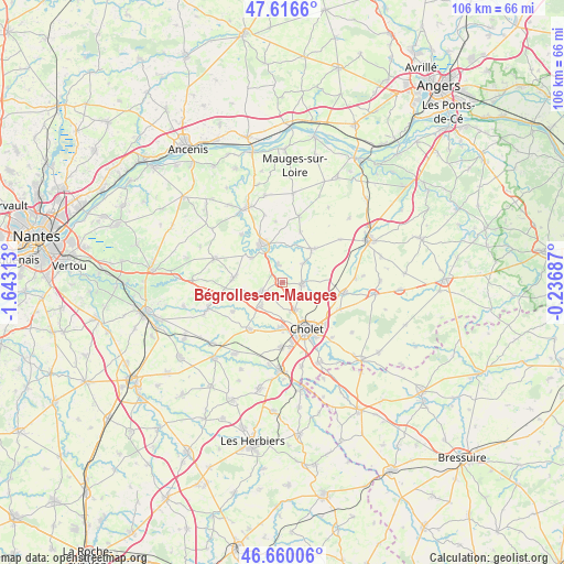
Bégrolles-en-Mauges GPS coordinates[2]
47° 8' 25.728" North, 0° 56' 24" West
| Map corner | latitude | longitude |
|---|---|---|
| Upper-left | 47.6166°, | -1.64313° |
| Center: | 47.14048°, | -0.94° |
| Lower-right: | 46.66006°, | -0.23687° |
| Map W x H: | 106.4×106.4 km | = 66.1×66.1mi |
| max Lat: | 51.07786° ⇑53.7% North |
| Bégrolles-en-Mauges: | 47.14048° |
| min Lat: | ⇓46.3% South 41.3874° |
| min Long | Bégrolles-en-M | max Long |
| -5.08615° | -0.94° | 9.52242° |
| W 12.3%⇐ | ⇒87.7% E |
Elevation
Elevation of Bégrolles-en-Mauges is 110 m = 361 ft, and this is 83.7 m = 275 ft below average elevation for this country.
| Max E: |
2333 m = 7654 ft | 57.3% |
| Avg. | 193.7 m = 635 ft | |
| Bégrolles-en-Mauges | 110 m = 361 ft | |
Min E: |
-1 m = -3 ft | 42.7% |
See also: France elevation on elevation.city.
Geographical zone
Bégrolles-en-Mauges is located in North temperate zone (between Tropic of Cancer and the Arctic Circle). Distance of this North polar circle is 2159.6 km =1341.9 mi to North.| Distance of | km | miles | from Bégrolles-en-Mauges |
|---|---|---|---|
| North Pole | 4765.5 | 2961.1 | to North |
| Arctic Circle | 2159.6 | 1341.9 | to North |
| Tropic Cancer | 2635.6 | 1637.7 | to South |
| Equator | 5241.5 | 3256.9 | to South |


Nearby cities:
15 places around Bégrolles-en-Mauges: (largest is in red/bold)
• Andrezé
3.6 km =2.2 mi,  344°
344°
• Beaupréau
8 km =5 mi,  333°
333°
• Cholet
10.1 km =6.3 mi,  153°
153°
• Jallais
8.3 km =5.2 mi,  41°
41°
• La Chapelle-du-Genêt
7.5 km =4.7 mi,  307°
307°
• La Jubaudière
5 km =3.1 mi,  45°
45°
• La Renaudière
9.3 km =5.8 mi,  255°
255°
• La Romagne
10.7 km =6.6 mi,  214°
214°
• La Séguinière
8.6 km =5.3 mi,  179°
179°
• Le May-sur-Èvre
3.6 km =2.2 mi,  95°
95°
• Roussay
10.9 km =6.8 mi,  239°
239°
• Saint-André-de-la-Marche
6.1 km =3.8 mi,  222°
222°
• Saint-Léger-sous-Cholet
5.6 km =3.5 mi,  156°
156°
• Saint-Macaire-en-Mauges
4.3 km =2.7 mi, 244°
• Villedieu-la-Blouère
9.3 km =5.8 mi,  274°
274°
Sources, notices
• [Note1] Compared only with cities in France existing in our database
• [Src1] Map data: © OpenStreetMap contributors (CC-BY-SA)
• [Src2] Other city data from geonames.org with taken over terms of usage.
• [Src3] Geographical zone / Annual Mean Temperature by Robert A. Rohde @ Wikipedia
