Andrezé geodata
Andrezé (Pays de la Loire) is a populated place; located in France in Europe/Paris (GMT+2) time zone. With population of 1,905 people, there are 5021 cities with bigger population in this country. Compared to other cities in France, 53.4% of cities are located further ↑North; 87.8% of cities are located further →East and 62.4% of cities have higher elevation than Andrezé. Note1
Administrative division(s):
- Level 1: Pays de la Loire
- Level 2: Département de Maine-et-Loire
- Level 3: Arrondissement de Cholet
- Level 4: Beaupréau-en-Mauges


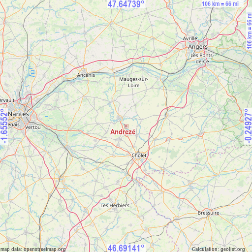
Andrezé GPS coordinates[2]
47° 10' 17.58" North, 0° 57' 8.604" West
| Map corner | latitude | longitude |
|---|---|---|
| Upper-left | 47.64739°, | -1.65552° |
| Center: | 47.17155°, | -0.95239° |
| Lower-right: | 46.69141°, | -0.24927° |
| Map W x H: | 106.3×106.3 km | = 66.1×66.1mi |
| max Lat: | 51.07786° ⇑53.4% North |
| Andrezé: | 47.17155° |
| min Lat: | ⇓46.6% South 41.3874° |
| min Long | Andrezé | max Long |
| -5.08615° | -0.95239° | 9.52242° |
| W 12.2%⇐ | ⇒87.8% E |
Elevation
Elevation of Andrezé is 96 m = 315 ft, and this is 97.7 m = 321 ft below average elevation for this country.
| Max E: |
2333 m = 7654 ft | 62.4% |
| Avg. | 193.7 m = 635 ft | |
| Andrezé | 96 m = 315 ft | |
Min E: |
-1 m = -3 ft | 37.6% |
See also: France elevation on elevation.city.
Geographical zone
Andrezé is located in North temperate zone (between Tropic of Cancer and the Arctic Circle). Distance of this North polar circle is 2156.2 km =1339.8 mi to North.| Distance of | km | miles | from Andrezé |
|---|---|---|---|
| North Pole | 4762.1 | 2959 | to North |
| Arctic Circle | 2156.2 | 1339.8 | to North |
| Tropic Cancer | 2639.1 | 1639.9 | to South |
| Equator | 5245 | 3259.1 | to South |


Nearby cities:
15 places around Andrezé: (largest is in red/bold)
• Beaupréau
4.5 km =2.8 mi,  324°
324°
• Bégrolles-en-Mauges
3.6 km =2.2 mi,  164°
164°
• Gesté
11.9 km =7.4 mi,  275°
275°
• Jallais
7 km =4.3 mi,  66°
66°
• La Chapelle-du-Genêt
5.1 km =3.2 mi, 283°
• La Jubaudière
4.6 km =2.9 mi,  89°
89°
• La Renaudière
9.9 km =6.2 mi,  234°
234°
• La Salle-et-Chapelle-Aubry
8.9 km =5.5 mi,  348°
348°
• Le Fief-Sauvin
8.8 km =5.5 mi,  309°
309°
• Le May-sur-Èvre
5.9 km =3.7 mi,  130°
130°
• Le Pin-en-Mauges
10 km =6.2 mi,  23°
23°
• Saint-André-de-la-Marche
8.6 km =5.3 mi,  201°
201°
• Saint-Léger-sous-Cholet
9.2 km =5.7 mi, 159°
• Saint-Macaire-en-Mauges
6.1 km =3.8 mi,  208°
208°
• Villedieu-la-Blouère
8.8 km =5.5 mi,  252°
252°
Sources, notices
• [Note1] Compared only with cities in France existing in our database
• [Src1] Map data: © OpenStreetMap contributors (CC-BY-SA)
• [Src2] Other city data from geonames.org with taken over terms of usage.
• [Src3] Geographical zone / Annual Mean Temperature by Robert A. Rohde @ Wikipedia
