Menthonnex-en-Bornes geodata
Menthonnex-en-Bornes (Auvergne-Rhône-Alpes) is a populated place; located in France in Europe/Paris (GMT+2) time zone. With population of 665 people, there are 12292 cities with bigger population in this country. Compared to other cities in France, 65.7% of cities are located further ↑North; 89% of cities are located further ←West and 97.8% of cities have lower elevation than Menthonnex-en-Bornes. Note1
Administrative division(s):
- Level 1: Auvergne-Rhône-Alpes
- Level 2: Haute-Savoie
- Level 3: Arrondissement de Saint-Julien-en-Genevois
- Level 4: Menthonnex-en-Bornes
Current local time in Menthonnex-en-Bornes:
04:42 AM, WednesdayDifference from your time zone: hours


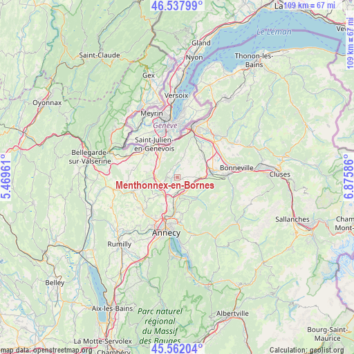
Menthonnex-en-Bornes GPS coordinates[2]
46° 3' 7.812" North, 6° 10' 21.828" East
| Map corner | latitude | longitude |
|---|---|---|
| Upper-left | 46.53799°, | 5.46961° |
| Center: | 46.05217°, | 6.17273° |
| Lower-right: | 45.56204°, | 6.87586° |
| Map W x H: | 108.5×108.5 km | = 67.4×67.4mi |
| max Lat: | 51.07786° ⇑65.7% North |
| Menthonnex-en-Bornes: | 46.05217° |
| min Lat: | ⇓34.3% South 41.3874° |
| min Long | Menthonnex-en-B | max Long |
| -5.08615° | 6.17273° | 9.52242° |
| W 89%⇐ | ⇒11% E |
Elevation
Elevation of Menthonnex-en-Bornes is 802 m = 2631 ft, and this is 608.3 m = 1996 ft above average elevation for this country.
| Max E: |
2333 m = 7654 ft | 2.2% |
| Menthonnex-en-Bornes | 802 m 2631 ft | |
| Avg. | 193.7 m = 635 ft | |
Min E: |
-1 m = -3 ft | 97.8% |
See also: France elevation on elevation.city.
Geographical zone
Menthonnex-en-Bornes is located in North temperate zone (between Tropic of Cancer and the Arctic Circle). Distance of this North polar circle is 2280.7 km =1417.2 mi to North.| Distance of | km | miles | from Menthonnex-en-Bornes |
|---|---|---|---|
| North Pole | 4886.5 | 3036.3 | to North |
| Arctic Circle | 2280.7 | 1417.2 | to North |
| Tropic Cancer | 2514.6 | 1562.5 | to South |
| Equator | 5120.5 | 3181.7 | to South |


Nearby cities:
15 places around Menthonnex-en-Bornes: (largest is in red/bold)
• Allonzier-la-Caille
7 km =4.3 mi,  216°
216°
• Andilly
8.3 km =5.2 mi,  274°
274°
• Arbusigny
5.8 km =3.6 mi,  37°
37°
• Aviernoz
9.3 km =5.8 mi,  152°
152°
• Beaumont
7 km =4.3 mi,  325°
325°
• Charvonnex
8.4 km =5.2 mi,  186°
186°
• Copponex
7.7 km =4.8 mi, 268°
• Cruseilles
5.6 km =3.5 mi,  243°
243°
• Groisy
4.7 km =2.9 mi,  182°
182°
• La Muraz
8.3 km =5.2 mi,  16°
16°
• Les Ollières
8.3 km =5.2 mi, 175°
• Neydens
9.4 km =5.8 mi, 325°
• Présilly
8.6 km =5.3 mi,  301°
301°
• Thorens-Glières
8.5 km =5.3 mi,  138°
138°
• Évires
4.3 km =2.7 mi,  111°
111°
Sources, notices
• [Note1] Compared only with cities in France existing in our database
• [Src1] Map data: © OpenStreetMap contributors (CC-BY-SA)
• [Src2] Other city data from geonames.org with taken over terms of usage.
• [Src3] Geographical zone / Annual Mean Temperature by Robert A. Rohde @ Wikipedia
