Beaulieu-sur-Mer geodata
Beaulieu-sur-Mer (Provence-Alpes-Côte d'Azur) is a populated place; located in France in Europe/Paris (GMT+2) time zone. With population of 3,824 people, there are 2576 cities with bigger population in this country. Compared to other cities in France, 90.3% of cities are located further ↑North; 96.8% of cities are located further ←West and 100% of cities have higher elevation than Beaulieu-sur-Mer. Note1
Administrative division(s):
- Level 1: Provence-Alpes-Côte d'Azur
- Level 2: Alpes-Maritimes
- Level 3: Arrondissement de Nice
- Level 4: Beaulieu-sur-Mer


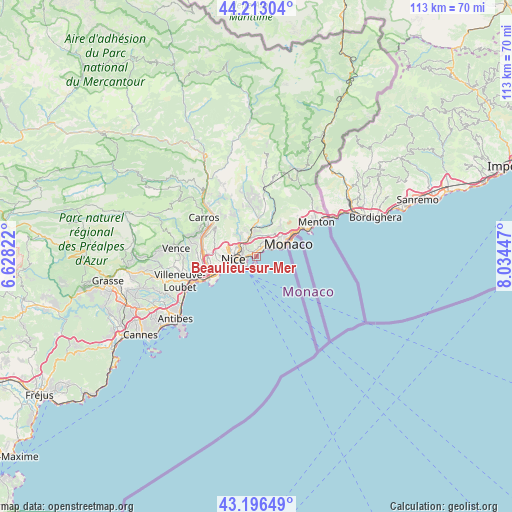
Beaulieu-sur-Mer GPS coordinates[2]
43° 42' 24.912" North, 7° 19' 52.86" East
| Map corner | latitude | longitude |
|---|---|---|
| Upper-left | 44.21304°, | 6.62822° |
| Center: | 43.70692°, | 7.33135° |
| Lower-right: | 43.19649°, | 8.03447° |
| Map W x H: | 113×113 km | = 70.2×70.2mi |
| max Lat: | 51.07786° ⇑90.3% North |
| Beaulieu-sur-Mer: | 43.70692° |
| min Lat: | ⇓9.7% South 41.3874° |
| min Long | Beaulieu-sur-Me | max Long |
| -5.08615° | 7.33135° | 9.52242° |
| W 96.8%⇐ | ⇒3.2% E |
Elevation
Elevation of Beaulieu-sur-Mer is 1 m = 3 ft, and this is 192.7 m = 632 ft below average elevation for this country.
| Max E: |
2333 m = 7654 ft | 100% |
| Avg. | 193.7 m = 635 ft | |
| Beaulieu-sur-Mer | 1 m = 3 ft | |
Min E: |
-1 m = -3 ft | 0% |
See also: France elevation on elevation.city.
Geographical zone
Beaulieu-sur-Mer is located in North temperate zone (between Tropic of Cancer and the Arctic Circle). Distance of this Northern Tropic circle is 2253.8 km =1400.4 mi to South.| Distance of | km | miles | from Beaulieu-sur-Mer |
|---|---|---|---|
| North Pole | 5147.3 | 3198.4 | to North |
| Arctic Circle | 2541.4 | 1579.2 | to North |
| Tropic Cancer | 2253.8 | 1400.4 | to South |
| Equator | 4859.8 | 3019.7 | to South |


Nearby cities:
15 places around Beaulieu-sur-Mer: (largest is in red/bold)
• Beausoleil
8.4 km =5.2 mi,  61°
61°
• Cantaron
6.2 km =3.9 mi,  349°
349°
• Cap-d’Ail
6.2 km =3.9 mi,  75°
75°
• Colomars
10.8 km =6.7 mi,  305°
305°
• Drap
5.4 km =3.4 mi, 351°
• Falicon
6.3 km =3.9 mi,  317°
317°
• La Trinité
4 km =2.5 mi,  339°
339°
• La Turbie
7 km =4.3 mi,  52°
52°
• Nice
5.3 km =3.3 mi,  265°
265°
• Peillon
9 km =5.6 mi,  27°
27°
• Saint-André-de-la-Roche
4.8 km =3 mi, 307°
• Saint-Jean-Cap-Ferrat
2.1 km =1.3 mi,  174°
174°
• Tourrette-Levens
9.9 km =6.2 mi,  333°
333°
• Villefranche-sur-Mer
1.7 km =1.1 mi,  258°
258°
• Èze
3.4 km =2.1 mi, 46°
Sources, notices
• [Note1] Compared only with cities in France existing in our database
• [Src1] Map data: © OpenStreetMap contributors (CC-BY-SA)
• [Src2] Other city data from geonames.org with taken over terms of usage.
• [Src3] Geographical zone / Annual Mean Temperature by Robert A. Rohde @ Wikipedia
