Saint-André-de-la-Roche geodata
Saint-André-de-la-Roche (Provence-Alpes-Côte d'Azur) is a populated place; located in France in Europe/Paris (GMT+2) time zone. With population of 4,336 people, there are 2275 cities with bigger population in this country. Compared to other cities in France, 89.9% of cities are located further ↑North; 96.4% of cities are located further ←West and 62% of cities have higher elevation than Saint-André-de-la-Roche. Note1
Administrative division(s):
- Level 1: Provence-Alpes-Côte d'Azur
- Level 2: Alpes-Maritimes
- Level 3: Arrondissement de Nice
- Level 4: Saint-André-de-la-Roche
Current local time in Saint-André-de-la-Roche:
01:43 PM, WednesdayDifference from your time zone: hours


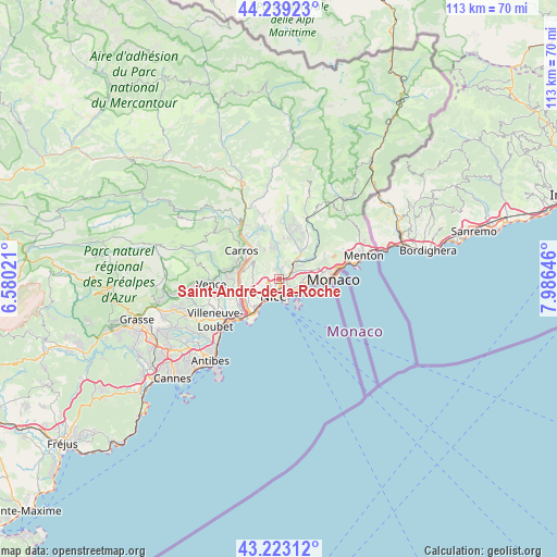
Saint-André-de-la-Roche GPS coordinates[2]
43° 43' 59.988" North, 7° 16' 59.988" East
| Map corner | latitude | longitude |
|---|---|---|
| Upper-left | 44.23923°, | 6.58021° |
| Center: | 43.73333°, | 7.28333° |
| Lower-right: | 43.22312°, | 7.98646° |
| Map W x H: | 113×113 km | = 70.2×70.2mi |
| max Lat: | 51.07786° ⇑89.9% North |
| Saint-André-de-la-Roche: | 43.73333° |
| min Lat: | ⇓10.1% South 41.3874° |
| min Long | Saint-André-de | max Long |
| -5.08615° | 7.28333° | 9.52242° |
| W 96.4%⇐ | ⇒3.6% E |
Elevation
Elevation of Saint-André-de-la-Roche is 97 m = 318 ft, and this is 96.7 m = 317 ft below average elevation for this country.
| Max E: |
2333 m = 7654 ft | 62% |
| Avg. | 193.7 m = 635 ft | |
| Saint-André-de-la-Roche | 97 m = 318 ft | |
Min E: |
-1 m = -3 ft | 38% |
See also: France elevation on elevation.city.
Geographical zone
Saint-André-de-la-Roche is located in North temperate zone (between Tropic of Cancer and the Arctic Circle). Distance of this Northern Tropic circle is 2256.8 km =1402.3 mi to South.| Distance of | km | miles | from Saint-André-de-la-Roche |
|---|---|---|---|
| North Pole | 5144.4 | 3196.6 | to North |
| Arctic Circle | 2538.5 | 1577.4 | to North |
| Tropic Cancer | 2256.8 | 1402.3 | to South |
| Equator | 4862.7 | 3021.5 | to South |


Nearby cities:
15 places around Saint-André-de-la-Roche: (largest is in red/bold)
• Aspremont
6.4 km =4 mi,  330°
330°
• Beaulieu-sur-Mer
4.8 km =3 mi,  127°
127°
• Cantaron
4.2 km =2.6 mi,  40°
40°
• Castagniers
7.7 km =4.8 mi, 327°
• Colomars
5.9 km =3.7 mi,  303°
303°
• Contes
9.2 km =5.7 mi,  15°
15°
• Drap
3.9 km =2.4 mi,  51°
51°
• Falicon
1.7 km =1.1 mi,  347°
347°
• Gattières
9.1 km =5.7 mi,  288°
288°
• La Trinité
2.6 km =1.6 mi,  72°
72°
• Nice
3.6 km =2.2 mi,  202°
202°
• Saint-Jean-Cap-Ferrat
6.4 km =4 mi,  141°
141°
• Tourrette-Levens
5.9 km =3.7 mi, 354°
• Villefranche-sur-Mer
3.9 km =2.4 mi,  145°
145°
• Èze
6.3 km =3.9 mi,  95°
95°
Sources, notices
• [Note1] Compared only with cities in France existing in our database
• [Src1] Map data: © OpenStreetMap contributors (CC-BY-SA)
• [Src2] Other city data from geonames.org with taken over terms of usage.
• [Src3] Geographical zone / Annual Mean Temperature by Robert A. Rohde @ Wikipedia
