Colomars geodata
Colomars (Provence-Alpes-Côte d'Azur) is a populated place; located in France in Europe/Paris (GMT+2) time zone. With population of 3,185 people, there are 3059 cities with bigger population in this country. Compared to other cities in France, 89.5% of cities are located further ↑North; 95.9% of cities are located further ←West and 80.3% of cities have lower elevation than Colomars. Note1
Administrative division(s):
- Level 1: Provence-Alpes-Côte d'Azur
- Level 2: Alpes-Maritimes
- Level 3: Arrondissement de Nice
- Level 4: Colomars


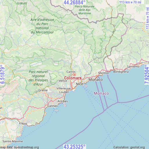
Colomars GPS coordinates[2]
43° 45' 47.52" North, 7° 13' 18.876" East
| Map corner | latitude | longitude |
|---|---|---|
| Upper-left | 44.26884°, | 6.51879° |
| Center: | 43.7632°, | 7.22191° |
| Lower-right: | 43.25325°, | 7.92504° |
| Map W x H: | 112.9×112.9 km | = 70.2×70.2mi |
| max Lat: | 51.07786° ⇑89.5% North |
| Colomars: | 43.7632° |
| min Lat: | ⇓10.5% South 41.3874° |
| min Long | Colomars | max Long |
| -5.08615° | 7.22191° | 9.52242° |
| W 95.9%⇐ | ⇒4.1% E |
Elevation
Elevation of Colomars is 293 m = 961 ft, and this is 99.3 m = 326 ft above average elevation for this country.
| Max E: |
2333 m = 7654 ft | 19.7% |
| Colomars | 293 m 961 ft | |
| Avg. | 193.7 m = 635 ft | |
Min E: |
-1 m = -3 ft | 80.3% |
See also: France elevation on elevation.city.
Geographical zone
Colomars is located in North temperate zone (between Tropic of Cancer and the Arctic Circle). Distance of this Northern Tropic circle is 2260.1 km =1404.4 mi to South.| Distance of | km | miles | from Colomars |
|---|---|---|---|
| North Pole | 5141.1 | 3194.5 | to North |
| Arctic Circle | 2535.2 | 1575.3 | to North |
| Tropic Cancer | 2260.1 | 1404.4 | to South |
| Equator | 4866 | 3023.6 | to South |


Nearby cities:
15 places around Colomars: (largest is in red/bold)
• Aspremont
2.9 km =1.8 mi,  38°
38°
• Cantaron
7.7 km =4.8 mi,  90°
90°
• Carros
4.3 km =2.7 mi,  319°
319°
• Castagniers
3.2 km =2 mi,  13°
13°
• Falicon
4.8 km =3 mi,  109°
109°
• Gattières
3.7 km =2.3 mi,  263°
263°
• La Gaude
7.2 km =4.5 mi,  230°
230°
• La Roquette-sur-Var
7.4 km =4.6 mi,  345°
345°
• Le Broc
6.6 km =4.1 mi, 319°
• Nice
7.6 km =4.7 mi,  152°
152°
• Saint-André-de-la-Roche
5.9 km =3.7 mi,  123°
123°
• Saint-Blaise
6.6 km =4.1 mi, 11°
• Saint-Jeannet
6.6 km =4.1 mi,  254°
254°
• Saint-Martin-du-Var
6.6 km =4.1 mi,  337°
337°
• Tourrette-Levens
5 km =3.1 mi,  59°
59°
Sources, notices
• [Note1] Compared only with cities in France existing in our database
• [Src1] Map data: © OpenStreetMap contributors (CC-BY-SA)
• [Src2] Other city data from geonames.org with taken over terms of usage.
• [Src3] Geographical zone / Annual Mean Temperature by Robert A. Rohde @ Wikipedia
