Bazincourt-sur-Epte geodata
Bazincourt-sur-Epte (Normandy) is a populated place; located in France in Europe/Paris (GMT+2) time zone. With population of 609 people, there are 13174 cities with bigger population in this country. Compared to other cities in France, 86.3% of cities are located further ↓South; 59.8% of cities are located further →East and 70.1% of cities have higher elevation than Bazincourt-sur-Epte. Note1
Administrative division(s):
- Level 1: Normandy
- Level 2: Département de l'Eure
- Level 3: Les Andelys
- Level 4: Bazincourt-sur-Epte


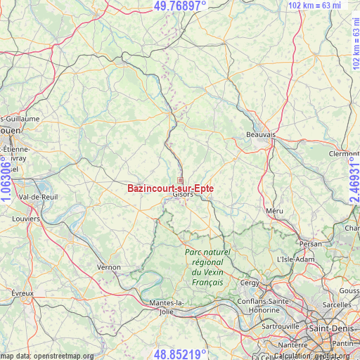
Bazincourt-sur-Epte GPS coordinates[2]
49° 18' 45.756" North, 1° 45' 58.284" East
| Map corner | latitude | longitude |
|---|---|---|
| Upper-left | 49.76897°, | 1.06306° |
| Center: | 49.31271°, | 1.76619° |
| Lower-right: | 48.85219°, | 2.46931° |
| Map W x H: | 101.9×101.9 km | = 63.3×63.3mi |
| max Lat: | 51.07786° ⇑13.7% North |
| Bazincourt-sur-Epte: | 49.31271° |
| min Lat: | ⇓86.3% South 41.3874° |
| min Long | Bazincourt-sur- | max Long |
| -5.08615° | 1.76619° | 9.52242° |
| W 40.2%⇐ | ⇒59.8% E |
Elevation
Elevation of Bazincourt-sur-Epte is 78 m = 256 ft, and this is 115.7 m = 380 ft below average elevation for this country.
| Max E: |
2333 m = 7654 ft | 70.1% |
| Avg. | 193.7 m = 635 ft | |
| Bazincourt-sur-Epte | 78 m = 256 ft | |
Min E: |
-1 m = -3 ft | 29.9% |
See also: France elevation on elevation.city.
Geographical zone
Bazincourt-sur-Epte is located in North temperate zone (between Tropic of Cancer and the Arctic Circle). Distance of this North polar circle is 1918.1 km =1191.9 mi to North.| Distance of | km | miles | from Bazincourt-sur-Epte |
|---|---|---|---|
| North Pole | 4524 | 2811.1 | to North |
| Arctic Circle | 1918.1 | 1191.9 | to North |
| Tropic Cancer | 2877.1 | 1787.7 | to South |
| Equator | 5483.1 | 3407 | to South |


Nearby cities:
15 places around Bazincourt-sur-Epte: (largest is in red/bold)
• Bézu-Saint-Éloi
4.9 km =3 mi,  246°
246°
• Chaumont-en-Vexin
10.1 km =6.3 mi,  120°
120°
• Courcelles-lès-Gisors
6.2 km =3.9 mi,  196°
196°
• Dangu
8.4 km =5.2 mi,  217°
217°
• Delincourt
8.5 km =5.3 mi,  145°
145°
• Flavacourt
4.6 km =2.9 mi,  57°
57°
• Gisors
3.6 km =2.2 mi,  163°
163°
• Heudicourt
8.2 km =5.1 mi,  289°
289°
• Hébécourt
5.3 km =3.3 mi,  327°
327°
• Lalande-en-Son
8.9 km =5.5 mi,  7°
7°
• Neaufles-Saint-Martin
4.9 km =3 mi,  214°
214°
• Sérifontaine
4.6 km =2.9 mi,  2°
2°
• Talmontiers
8.2 km =5.1 mi,  348°
348°
• Trie-Château
5 km =3.1 mi,  127°
127°
• Éragny-sur-Epte
0.7 km =0.4 mi,  67°
67°
Sources, notices
• [Note1] Compared only with cities in France existing in our database
• [Src1] Map data: © OpenStreetMap contributors (CC-BY-SA)
• [Src2] Other city data from geonames.org with taken over terms of usage.
• [Src3] Geographical zone / Annual Mean Temperature by Robert A. Rohde @ Wikipedia
