Dangu geodata
Dangu (Normandy) is a populated place; located in France in Europe/Paris (GMT+2) time zone. With population of 619 people, there are 13004 cities with bigger population in this country. Compared to other cities in France, 85.2% of cities are located further ↓South; 60.5% of cities are located further →East and 74.1% of cities have higher elevation than Dangu. Note1
Administrative division(s):
- Level 1: Normandy
- Level 2: Département de l'Eure
- Level 3: Les Andelys
- Level 4: Dangu


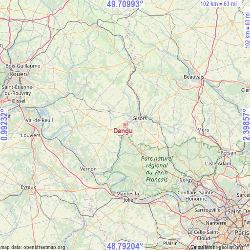
Dangu GPS coordinates[2]
49° 15' 11.232" North, 1° 41' 43.62" East
| Map corner | latitude | longitude |
|---|---|---|
| Upper-left | 49.70993°, | 0.99232° |
| Center: | 49.25312°, | 1.69545° |
| Lower-right: | 48.79204°, | 2.39857° |
| Map W x H: | 102.1×102.1 km | = 63.4×63.4mi |
| max Lat: | 51.07786° ⇑14.8% North |
| Dangu: | 49.25312° |
| min Lat: | ⇓85.2% South 41.3874° |
| min Long | Dangu | max Long |
| -5.08615° | 1.69545° | 9.52242° |
| W 39.5%⇐ | ⇒60.5% E |
Elevation
Elevation of Dangu is 69 m = 226 ft, and this is 124.7 m = 409 ft below average elevation for this country.
| Max E: |
2333 m = 7654 ft | 74.1% |
| Avg. | 193.7 m = 635 ft | |
| Dangu | 69 m = 226 ft | |
Min E: |
-1 m = -3 ft | 25.9% |
See also: France elevation on elevation.city.
Geographical zone
Dangu is located in North temperate zone (between Tropic of Cancer and the Arctic Circle). Distance of this North polar circle is 1924.7 km =1196 mi to North.| Distance of | km | miles | from Dangu |
|---|---|---|---|
| North Pole | 4530.6 | 2815.2 | to North |
| Arctic Circle | 1924.7 | 1196 | to North |
| Tropic Cancer | 2870.5 | 1783.6 | to South |
| Equator | 5476.4 | 3402.9 | to South |


Nearby cities:
15 places around Dangu: (largest is in red/bold)
• Bazincourt-sur-Epte
8.4 km =5.2 mi,  37°
37°
• Bézu-Saint-Éloi
4.7 km =2.9 mi,  7°
7°
• Château-sur-Epte
6.6 km =4.1 mi,  201°
201°
• Courcelles-lès-Gisors
3.4 km =2.1 mi,  77°
77°
• Delincourt
10 km =6.2 mi,  91°
91°
• Gisors
6.9 km =4.3 mi,  62°
62°
• Heudicourt
9.7 km =6 mi,  344°
344°
• Les Thilliers-en-Vexin
6.8 km =4.2 mi,  254°
254°
• Montagny-en-Vexin
9.9 km =6.2 mi,  129°
129°
• Neaufles-Saint-Martin
3.5 km =2.2 mi, 42°
• Saint-Clair-sur-Epte
5.1 km =3.2 mi,  191°
191°
• Trie-Château
9.8 km =6.1 mi,  68°
68°
• Vesly
3.3 km =2.1 mi, 250°
• Éragny-sur-Epte
9 km =5.6 mi, 39°
• Étrépagny
8.5 km =5.3 mi,  314°
314°
Sources, notices
• [Note1] Compared only with cities in France existing in our database
• [Src1] Map data: © OpenStreetMap contributors (CC-BY-SA)
• [Src2] Other city data from geonames.org with taken over terms of usage.
• [Src3] Geographical zone / Annual Mean Temperature by Robert A. Rohde @ Wikipedia
