Trans-en-Provence geodata
Trans-en-Provence (Provence-Alpes-Côte d'Azur) is a populated place; located in France in Europe/Paris (GMT+2) time zone. With population of 5,209 people, there are 1890 cities with bigger population in this country. Compared to other cities in France, 93% of cities are located further ↑North; 91.6% of cities are located further ←West and 59.6% of cities have lower elevation than Trans-en-Provence. Note1
Administrative division(s):
- Level 1: Provence-Alpes-Côte d'Azur
- Level 2: Var
- Level 3: Arrondissement de Draguignan
- Level 4: Trans-en-Provence


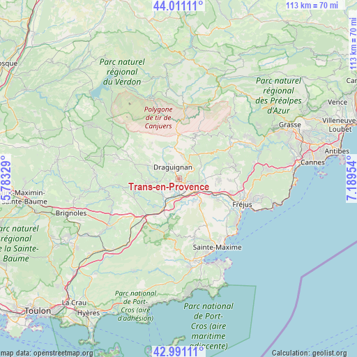
Trans-en-Provence GPS coordinates[2]
43° 30' 11.736" North, 6° 29' 11.076" East
| Map corner | latitude | longitude |
|---|---|---|
| Upper-left | 44.01111°, | 5.78329° |
| Center: | 43.50326°, | 6.48641° |
| Lower-right: | 42.99111°, | 7.18954° |
| Map W x H: | 113.4×113.4 km | = 70.5×70.5mi |
| max Lat: | 51.07786° ⇑93% North |
| Trans-en-Provence: | 43.50326° |
| min Lat: | ⇓7% South 41.3874° |
| min Long | Trans-en-Proven | max Long |
| -5.08615° | 6.48641° | 9.52242° |
| W 91.6%⇐ | ⇒8.4% E |
Elevation
Elevation of Trans-en-Provence is 168 m = 551 ft, and this is 25.7 m = 84 ft below average elevation for this country.
| Max E: |
2333 m = 7654 ft | 40.4% |
| Avg. | 193.7 m = 635 ft | |
| Trans-en-Provence | 168 m = 551 ft | |
Min E: |
-1 m = -3 ft | 59.6% |
See also: France elevation on elevation.city.
Geographical zone
Trans-en-Provence is located in North temperate zone (between Tropic of Cancer and the Arctic Circle). Distance of this Northern Tropic circle is 2231.2 km =1386.4 mi to South.| Distance of | km | miles | from Trans-en-Provence |
|---|---|---|---|
| North Pole | 5170 | 3212.5 | to North |
| Arctic Circle | 2564.1 | 1593.3 | to North |
| Tropic Cancer | 2231.2 | 1386.4 | to South |
| Equator | 4837.1 | 3005.6 | to South |


Nearby cities:
15 places around Trans-en-Provence: (largest is in red/bold)
• Ampus
14.3 km =8.9 mi,  323°
323°
• Bargemon
13.8 km =8.6 mi,  21°
21°
• Callas
10.8 km =6.7 mi, 22°
• Claviers
12.6 km =7.8 mi,  29°
29°
• Draguignan
4.1 km =2.5 mi,  334°
334°
• Figanières
7.3 km =4.5 mi,  6°
6°
• Flayosc
8 km =5 mi,  295°
295°
• La Motte
4.1 km =2.5 mi,  104°
104°
• Le Muy
7.3 km =4.5 mi,  117°
117°
• Les Arcs
4.5 km =2.8 mi,  187°
187°
• Lorgues
10.1 km =6.3 mi,  263°
263°
• Montferrat
12.1 km =7.5 mi,  357°
357°
• Roquebrune-sur-Argens
13.9 km =8.6 mi, 118°
• Taradeau
7.2 km =4.5 mi,  221°
221°
• Vidauban
9.5 km =5.9 mi,  207°
207°
Sources, notices
• [Note1] Compared only with cities in France existing in our database
• [Src1] Map data: © OpenStreetMap contributors (CC-BY-SA)
• [Src2] Other city data from geonames.org with taken over terms of usage.
• [Src3] Geographical zone / Annual Mean Temperature by Robert A. Rohde @ Wikipedia
