Bailly-en-Rivière geodata
Bailly-en-Rivière (Normandy) is a populated place; located in France in Europe/Paris (GMT+2) time zone. With population of 511 people, there are 15016 cities with bigger population in this country. Compared to other cities in France, 93.1% of cities are located further ↓South; 65.2% of cities are located further →East and 71% of cities have higher elevation than Bailly-en-Rivière. Note1
Administrative division(s):
- Level 1: Normandy
- Level 2: Seine-Maritime
- Level 3: Arrondissement de Dieppe
- Level 4: Bailly-en-Rivière


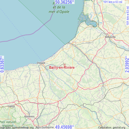
Bailly-en-Rivière GPS coordinates[2]
49° 54' 42.84" North, 1° 20' 12.444" East
| Map corner | latitude | longitude |
|---|---|---|
| Upper-left | 50.36256°, | 0.63367° |
| Center: | 49.9119°, | 1.33679° |
| Lower-right: | 49.45698°, | 2.03992° |
| Map W x H: | 100.7×100.7 km | = 62.6×62.6mi |
| max Lat: | 51.07786° ⇑6.9% North |
| Bailly-en-Rivière: | 49.9119° |
| min Lat: | ⇓93.1% South 41.3874° |
| min Long | Bailly-en-Rivi� | max Long |
| -5.08615° | 1.33679° | 9.52242° |
| W 34.8%⇐ | ⇒65.2% E |
Elevation
Elevation of Bailly-en-Rivière is 76 m = 249 ft, and this is 117.7 m = 386 ft below average elevation for this country.
| Max E: |
2333 m = 7654 ft | 71% |
| Avg. | 193.7 m = 635 ft | |
| Bailly-en-Rivière | 76 m = 249 ft | |
Min E: |
-1 m = -3 ft | 29% |
See also: France elevation on elevation.city.
Geographical zone
Bailly-en-Rivière is located in North temperate zone (between Tropic of Cancer and the Arctic Circle). Distance of this North polar circle is 1851.5 km =1150.5 mi to North.| Distance of | km | miles | from Bailly-en-Rivière |
|---|---|---|---|
| North Pole | 4457.4 | 2769.7 | to North |
| Arctic Circle | 1851.5 | 1150.5 | to North |
| Tropic Cancer | 2943.8 | 1829.2 | to South |
| Equator | 5549.7 | 3448.4 | to South |


Nearby cities:
15 places around Bailly-en-Rivière: (largest is in red/bold)
• Ancourt
11 km =6.8 mi,  268°
268°
• Belleville-sur-Mer
13.1 km =8.1 mi,  288°
288°
• Berneval-le-Grand
11.6 km =7.2 mi, 293°
• Bracquemont
14.1 km =8.8 mi,  282°
282°
• Criel-sur-Mer
11.6 km =7.2 mi,  352°
352°
• Envermeu
5.5 km =3.4 mi,  250°
250°
• Fresnoy-Folny
7.1 km =4.4 mi,  111°
111°
• Grèges
13.6 km =8.5 mi, 274°
• Londinières
10.1 km =6.3 mi,  152°
152°
• Martin-Église
14.1 km =8.8 mi, 265°
• Monchy-sur-Eu
12.5 km =7.8 mi,  42°
42°
• Saint-Aubin-le-Cauf
12 km =7.5 mi, 245°
• Saint-Martin-en-Campagne
9.6 km =6 mi,  301°
301°
• Saint-Nicolas-d’Aliermont
8.8 km =5.5 mi, 245°
• Saint-Vaast-d’Équiqueville
11.7 km =7.3 mi,  205°
205°
Sources, notices
• [Note1] Compared only with cities in France existing in our database
• [Src1] Map data: © OpenStreetMap contributors (CC-BY-SA)
• [Src2] Other city data from geonames.org with taken over terms of usage.
• [Src3] Geographical zone / Annual Mean Temperature by Robert A. Rohde @ Wikipedia
