Londinières geodata
Londinières (Normandy) is a populated place; located in France in Europe/Paris (GMT+2) time zone. With population of 1,195 people, there are 7564 cities with bigger population in this country. Compared to other cities in France, 92.5% of cities are located further ↓South; 64.2% of cities are located further →East and 71.4% of cities have higher elevation than Londinières. Note1
Administrative division(s):
- Level 1: Normandy
- Level 2: Seine-Maritime
- Level 3: Arrondissement de Dieppe
- Level 4: Londinières


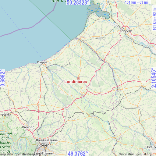
Londinières GPS coordinates[2]
49° 49' 54.732" North, 1° 24' 8.352" East
| Map corner | latitude | longitude |
|---|---|---|
| Upper-left | 50.28328°, | 0.6992° |
| Center: | 49.83187°, | 1.40232° |
| Lower-right: | 49.3762°, | 2.10545° |
| Map W x H: | 100.9×100.9 km | = 62.7×62.7mi |
| max Lat: | 51.07786° ⇑7.5% North |
| Londinières: | 49.83187° |
| min Lat: | ⇓92.5% South 41.3874° |
| min Long | Londinières | max Long |
| -5.08615° | 1.40232° | 9.52242° |
| W 35.8%⇐ | ⇒64.2% E |
Elevation
Elevation of Londinières is 75 m = 246 ft, and this is 118.7 m = 389 ft below average elevation for this country.
| Max E: |
2333 m = 7654 ft | 71.4% |
| Avg. | 193.7 m = 635 ft | |
| Londinières | 75 m = 246 ft | |
Min E: |
-1 m = -3 ft | 28.6% |
See also: France elevation on elevation.city.
Geographical zone
Londinières is located in North temperate zone (between Tropic of Cancer and the Arctic Circle). Distance of this North polar circle is 1860.4 km =1156 mi to North.| Distance of | km | miles | from Londinières |
|---|---|---|---|
| North Pole | 4466.3 | 2775.2 | to North |
| Arctic Circle | 1860.4 | 1156 | to North |
| Tropic Cancer | 2934.9 | 1823.7 | to South |
| Equator | 5540.8 | 3442.9 | to South |


Nearby cities:
15 places around Londinières: (largest is in red/bold)
• Ancourt
17.9 km =11.1 mi,  298°
298°
• Bailly-en-Rivière
10.1 km =6.3 mi,  332°
332°
• Bully
11.9 km =7.4 mi,  191°
191°
• Envermeu
12.1 km =7.5 mi,  305°
305°
• Foucarmont
12.1 km =7.5 mi,  82°
82°
• Fresnoy-Folny
6.5 km =4 mi,  16°
16°
• Les Grandes-Ventes
13.5 km =8.4 mi,  247°
247°
• Mesnières-en-Bray
7.9 km =4.9 mi, 190°
• Neufchâtel-en-Bray
11.3 km =7 mi,  166°
166°
• Neuville-Ferrières
13.9 km =8.6 mi,  163°
163°
• Rieux
17.3 km =10.7 mi,  48°
48°
• Saint-Aubin-le-Cauf
16.1 km =10 mi,  284°
284°
• Saint-Nicolas-d’Aliermont
13.7 km =8.5 mi,  292°
292°
• Saint-Vaast-d’Équiqueville
9.9 km =6.2 mi,  260°
260°
• Torcy-le-Grand
16.7 km =10.4 mi, 257°
Sources, notices
• [Note1] Compared only with cities in France existing in our database
• [Src1] Map data: © OpenStreetMap contributors (CC-BY-SA)
• [Src2] Other city data from geonames.org with taken over terms of usage.
• [Src3] Geographical zone / Annual Mean Temperature by Robert A. Rohde @ Wikipedia
