Cachan geodata
Cachan (Île-de-France) is a populated place; located in France in Europe/Paris (GMT+2) time zone. With population of 26,540 people, there are 325 cities with bigger population in this country. Compared to other cities in France, 75.5% of cities are located further ↓South; 52.1% of cities are located further →East and 83.1% of cities have higher elevation than Cachan. Note1
Administrative division(s):
- Level 1: Île-de-France
- Level 2: Val-de-Marne
- Level 3: Arrondissement de L'Haÿ-les-Roses
- Level 4: Cachan


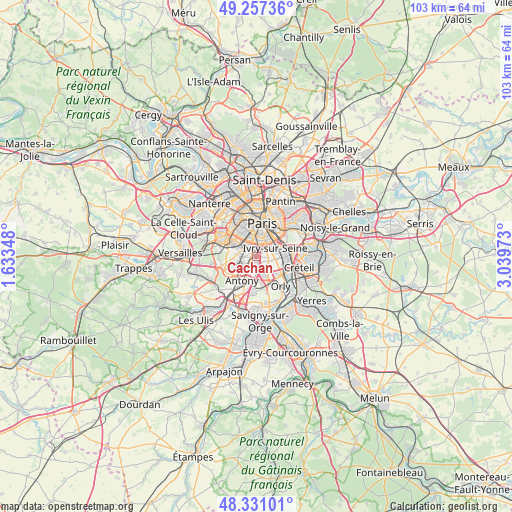
Cachan GPS coordinates[2]
48° 47' 46.752" North, 2° 20' 11.796" East
| Map corner | latitude | longitude |
|---|---|---|
| Upper-left | 49.25736°, | 1.63348° |
| Center: | 48.79632°, | 2.33661° |
| Lower-right: | 48.33101°, | 3.03973° |
| Map W x H: | 103×103 km | = 64×64mi |
| max Lat: | 51.07786° ⇑24.5% North |
| Cachan: | 48.79632° |
| min Lat: | ⇓75.5% South 41.3874° |
| min Long | Cachan | max Long |
| -5.08615° | 2.33661° | 9.52242° |
| W 47.9%⇐ | ⇒52.1% E |
Elevation
Elevation of Cachan is 47 m = 154 ft, and this is 146.7 m = 481 ft below average elevation for this country.
| Max E: |
2333 m = 7654 ft | 83.1% |
| Avg. | 193.7 m = 635 ft | |
| Cachan | 47 m = 154 ft | |
Min E: |
-1 m = -3 ft | 16.9% |
See also: France elevation on elevation.city.
Geographical zone
Cachan is located in North temperate zone (between Tropic of Cancer and the Arctic Circle). Distance of this North polar circle is 1975.5 km =1227.5 mi to North.| Distance of | km | miles | from Cachan |
|---|---|---|---|
| North Pole | 4581.4 | 2846.7 | to North |
| Arctic Circle | 1975.5 | 1227.5 | to North |
| Tropic Cancer | 2819.7 | 1752.1 | to South |
| Equator | 5425.6 | 3371.3 | to South |


Nearby cities:
15 places around Cachan: (largest is in red/bold)
• Arcueil
0.5 km =0.3 mi,  323°
323°
• Bagneux
2.1 km =1.3 mi,  267°
267°
• Bourg-la-Reine
2.4 km =1.5 mi,  215°
215°
• Chevilly-Larue
3.6 km =2.2 mi,  164°
164°
• Châtillon
3.2 km =2 mi,  282°
282°
• Fontenay-aux-Roses
3.2 km =2 mi,  263°
263°
• Gentilly
1.9 km =1.2 mi,  11°
11°
• Ivry-sur-Seine
4.1 km =2.5 mi,  58°
58°
• L'Haÿ-les-Roses
1.5 km =0.9 mi,  189°
189°
• Le Kremlin-Bicêtre
2.7 km =1.7 mi,  40°
40°
• Malakoff
3.8 km =2.4 mi,  314°
314°
• Montrouge
2.8 km =1.7 mi, 323°
• Sceaux
4.1 km =2.5 mi,  236°
236°
• Vanves
4.5 km =2.8 mi, 311°
• Villejuif
1.7 km =1.1 mi,  98°
98°
Sources, notices
• [Note1] Compared only with cities in France existing in our database
• [Src1] Map data: © OpenStreetMap contributors (CC-BY-SA)
• [Src2] Other city data from geonames.org with taken over terms of usage.
• [Src3] Geographical zone / Annual Mean Temperature by Robert A. Rohde @ Wikipedia
