Noizay geodata
Noizay (Centre) is a populated place; located in France in Europe/Paris (GMT+2) time zone. With population of 1,091 people, there are 8187 cities with bigger population in this country. Compared to other cities in France, 50.2% of cities are located further ↓South; 69.8% of cities are located further →East and 78.6% of cities have higher elevation than Noizay. Note1
Administrative division(s):
- Level 1: Centre
- Level 2: Département d'Indre-et-Loire
- Level 3: Arrondissement de Loches
- Level 4: Noizay


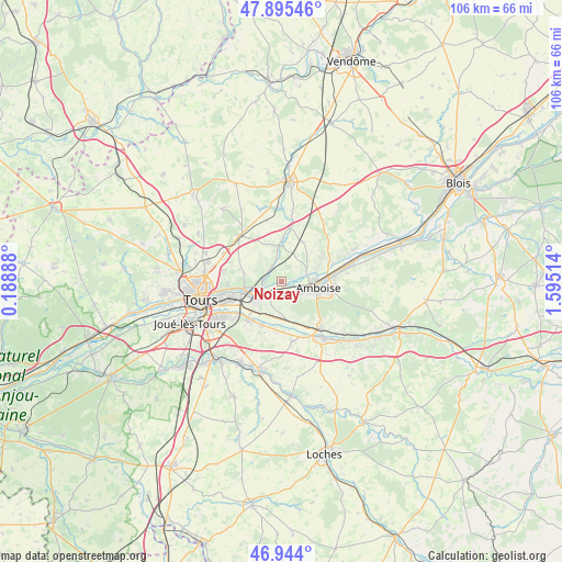
Noizay GPS coordinates[2]
47° 25' 18.768" North, 0° 53' 31.236" East
| Map corner | latitude | longitude |
|---|---|---|
| Upper-left | 47.89546°, | 0.18888° |
| Center: | 47.42188°, | 0.89201° |
| Lower-right: | 46.944°, | 1.59514° |
| Map W x H: | 105.8×105.8 km | = 65.7×65.7mi |
| max Lat: | 51.07786° ⇑49.8% North |
| Noizay: | 47.42188° |
| min Lat: | ⇓50.2% South 41.3874° |
| min Long | Noizay | max Long |
| -5.08615° | 0.89201° | 9.52242° |
| W 30.2%⇐ | ⇒69.8% E |
Elevation
Elevation of Noizay is 58 m = 190 ft, and this is 135.7 m = 445 ft below average elevation for this country.
| Max E: |
2333 m = 7654 ft | 78.6% |
| Avg. | 193.7 m = 635 ft | |
| Noizay | 58 m = 190 ft | |
Min E: |
-1 m = -3 ft | 21.4% |
See also: France elevation on elevation.city.
Geographical zone
Noizay is located in North temperate zone (between Tropic of Cancer and the Arctic Circle). Distance of this North polar circle is 2128.4 km =1322.5 mi to North.| Distance of | km | miles | from Noizay |
|---|---|---|---|
| North Pole | 4734.2 | 2941.7 | to North |
| Arctic Circle | 2128.4 | 1322.5 | to North |
| Tropic Cancer | 2666.9 | 1657.1 | to South |
| Equator | 5272.8 | 3276.4 | to South |


Nearby cities:
15 places around Noizay: (largest is in red/bold)
• Amboise
6.9 km =4.3 mi,  98°
98°
• Azay-sur-Cher
8.8 km =5.5 mi,  203°
203°
• Chançay
3.8 km =2.4 mi,  339°
339°
• La Ville-aux-Dames
9.8 km =6.1 mi,  252°
252°
• Lussault-sur-Loire
3.5 km =2.2 mi,  149°
149°
• Montlouis-sur-Loire
5.8 km =3.6 mi,  230°
230°
• Montreuil-en-Touraine
8.5 km =5.3 mi,  30°
30°
• Nazelles-Négron
4.5 km =2.8 mi,  73°
73°
• Pocé-sur-Cisse
7.8 km =4.8 mi, 72°
• Reugny
6.7 km =4.2 mi,  355°
355°
• Saint-Martin-le-Beau
7.5 km =4.7 mi,  169°
169°
• Saint-Ouen-les-Vignes
9.2 km =5.7 mi,  56°
56°
• Vernou-sur-Brenne
3.4 km =2.1 mi,  265°
265°
• Vouvray
7.1 km =4.4 mi,  260°
260°
• Véretz
9.7 km =6 mi,  222°
222°
Sources, notices
• [Note1] Compared only with cities in France existing in our database
• [Src1] Map data: © OpenStreetMap contributors (CC-BY-SA)
• [Src2] Other city data from geonames.org with taken over terms of usage.
• [Src3] Geographical zone / Annual Mean Temperature by Robert A. Rohde @ Wikipedia
