Lussault-sur-Loire geodata
Lussault-sur-Loire (Centre) is a populated place; located in France in Europe/Paris (GMT+2) time zone. With population of 696 people, there are 11855 cities with bigger population in this country. Compared to other cities in France, 50.2% of cities are located further ↑North; 69.6% of cities are located further →East and 71.9% of cities have higher elevation than Lussault-sur-Loire. Note1
Administrative division(s):
- Level 1: Centre
- Level 2: Département d'Indre-et-Loire
- Level 3: Arrondissement de Loches
- Level 4: Lussault-sur-Loire


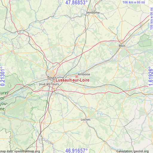
Lussault-sur-Loire GPS coordinates[2]
47° 23' 40.92" North, 0° 54' 58.068" East
| Map corner | latitude | longitude |
|---|---|---|
| Upper-left | 47.86853°, | 0.21301° |
| Center: | 47.3947°, | 0.91613° |
| Lower-right: | 46.91657°, | 1.61926° |
| Map W x H: | 105.8×105.8 km | = 65.7×65.7mi |
| max Lat: | 51.07786° ⇑50.2% North |
| Lussault-sur-Loire: | 47.3947° |
| min Lat: | ⇓49.8% South 41.3874° |
| min Long | Lussault-sur-Lo | max Long |
| -5.08615° | 0.91613° | 9.52242° |
| W 30.4%⇐ | ⇒69.6% E |
Elevation
Elevation of Lussault-sur-Loire is 74 m = 243 ft, and this is 119.7 m = 393 ft below average elevation for this country.
| Max E: |
2333 m = 7654 ft | 71.9% |
| Avg. | 193.7 m = 635 ft | |
| Lussault-sur-Loire | 74 m = 243 ft | |
Min E: |
-1 m = -3 ft | 28.1% |
See also: France elevation on elevation.city.
Geographical zone
Lussault-sur-Loire is located in North temperate zone (between Tropic of Cancer and the Arctic Circle). Distance of this North polar circle is 2131.4 km =1324.4 mi to North.| Distance of | km | miles | from Lussault-sur-Loire |
|---|---|---|---|
| North Pole | 4737.3 | 2943.6 | to North |
| Arctic Circle | 2131.4 | 1324.4 | to North |
| Tropic Cancer | 2663.9 | 1655.3 | to South |
| Equator | 5269.8 | 3274.5 | to South |


Nearby cities:
15 places around Lussault-sur-Loire: (largest is in red/bold)
• Amboise
5.4 km =3.4 mi,  68°
68°
• Athée-sur-Cher
8.3 km =5.2 mi,  179°
179°
• Azay-sur-Cher
7.3 km =4.5 mi,  226°
226°
• Bléré
9.4 km =5.8 mi,  142°
142°
• Chançay
7.3 km =4.5 mi,  334°
334°
• Dierre
6.3 km =3.9 mi,  150°
150°
• La Croix-en-Touraine
8.2 km =5.1 mi, 137°
• Montlouis-sur-Loire
6.4 km =4 mi,  263°
263°
• Nazelles-Négron
5 km =3.1 mi,  30°
30°
• Noizay
3.5 km =2.2 mi, 329°
• Pocé-sur-Cisse
7.8 km =4.8 mi,  46°
46°
• Saint-Martin-le-Beau
4.4 km =2.7 mi,  186°
186°
• Vernou-sur-Brenne
5.8 km =3.6 mi,  297°
297°
• Vouvray
9 km =5.6 mi,  281°
281°
• Véretz
9.3 km =5.8 mi,  243°
243°
Sources, notices
• [Note1] Compared only with cities in France existing in our database
• [Src1] Map data: © OpenStreetMap contributors (CC-BY-SA)
• [Src2] Other city data from geonames.org with taken over terms of usage.
• [Src3] Geographical zone / Annual Mean Temperature by Robert A. Rohde @ Wikipedia
