Ayse geodata
Ayse (Auvergne-Rhône-Alpes) is a populated place; located in France in Europe/Paris (GMT+2) time zone. With population of 2,024 people, there are 4731 cities with bigger population in this country. Compared to other cities in France, 65.3% of cities are located further ↑North; 91.4% of cities are located further ←West and 92.6% of cities have lower elevation than Ayse. Note1
Administrative division(s):
- Level 1: Auvergne-Rhône-Alpes
- Level 2: Haute-Savoie
- Level 3: Arrondissement de Bonneville
- Level 4: Ayse


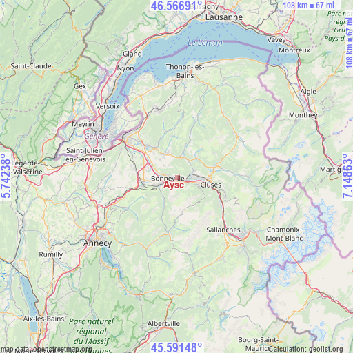
Ayse GPS coordinates[2]
46° 4' 52.86" North, 6° 26' 43.8" East
| Map corner | latitude | longitude |
|---|---|---|
| Upper-left | 46.56691°, | 5.74238° |
| Center: | 46.08135°, | 6.4455° |
| Lower-right: | 45.59148°, | 7.14863° |
| Map W x H: | 108.5×108.5 km | = 67.4×67.4mi |
| max Lat: | 51.07786° ⇑65.3% North |
| Ayse: | 46.08135° |
| min Lat: | ⇓34.7% South 41.3874° |
| min Long | Ayse | max Long |
| -5.08615° | 6.4455° | 9.52242° |
| W 91.4%⇐ | ⇒8.6% E |
Elevation
Elevation of Ayse is 491 m = 1611 ft, and this is 297.3 m = 975 ft above average elevation for this country.
| Max E: |
2333 m = 7654 ft | 7.4% |
| Ayse | 491 m 1611 ft | |
| Avg. | 193.7 m = 635 ft | |
Min E: |
-1 m = -3 ft | 92.6% |
See also: France elevation on elevation.city.
Geographical zone
Ayse is located in North temperate zone (between Tropic of Cancer and the Arctic Circle). Distance of this North polar circle is 2277.4 km =1415.1 mi to North.| Distance of | km | miles | from Ayse |
|---|---|---|---|
| North Pole | 4883.3 | 3034.3 | to North |
| Arctic Circle | 2277.4 | 1415.1 | to North |
| Tropic Cancer | 2517.8 | 1564.5 | to South |
| Equator | 5123.8 | 3183.8 | to South |


Nearby cities:
15 places around Ayse: (largest is in red/bold)
• Bonneville
3 km =1.9 mi,  267°
267°
• La Tour
5.9 km =3.7 mi,  349°
349°
• Marignier
4.3 km =2.7 mi,  76°
76°
• Marnaz
6.6 km =4.1 mi,  107°
107°
• Mieussy
8.4 km =5.2 mi,  46°
46°
• Mont-Saxonnex
4.1 km =2.5 mi,  146°
146°
• Peillonnex
7.4 km =4.6 mi,  314°
314°
• Saint-Jean-de-Tholome
5.3 km =3.3 mi, 311°
• Saint-Jeoire
6.3 km =3.9 mi,  11°
11°
• Saint-Laurent
7.8 km =4.8 mi,  239°
239°
• Scionzier
8.6 km =5.3 mi, 105°
• Thyez
7.1 km =4.4 mi,  88°
88°
• Ville-en-Sallaz
7.3 km =4.5 mi, 345°
• Viuz-en-Sallaz
7.8 km =4.8 mi,  338°
338°
• Vougy
2.5 km =1.6 mi,  126°
126°
Sources, notices
• [Note1] Compared only with cities in France existing in our database
• [Src1] Map data: © OpenStreetMap contributors (CC-BY-SA)
• [Src2] Other city data from geonames.org with taken over terms of usage.
• [Src3] Geographical zone / Annual Mean Temperature by Robert A. Rohde @ Wikipedia
