Saint-Jeoire geodata
Saint-Jeoire (Auvergne-Rhône-Alpes) is a populated place; located in France in Europe/Paris (GMT+2) time zone. With population of 3,006 people, there are 3246 cities with bigger population in this country. Compared to other cities in France, 64.5% of cities are located further ↑North; 91.5% of cities are located further ←West and 94.7% of cities have lower elevation than Saint-Jeoire. Note1
Administrative division(s):
- Level 1: Auvergne-Rhône-Alpes
- Level 2: Haute-Savoie
- Level 3: Arrondissement de Bonneville
- Level 4: Saint-Jeoire


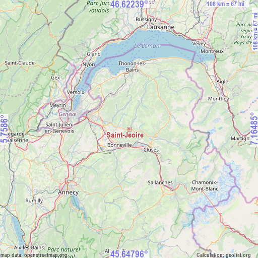
Saint-Jeoire GPS coordinates[2]
46° 8' 14.388" North, 6° 27' 42.192" East
| Map corner | latitude | longitude |
|---|---|---|
| Upper-left | 46.62239°, | 5.7586° |
| Center: | 46.13733°, | 6.46172° |
| Lower-right: | 45.64796°, | 7.16485° |
| Map W x H: | 108.3×108.3 km | = 67.3×67.3mi |
| max Lat: | 51.07786° ⇑64.5% North |
| Saint-Jeoire: | 46.13733° |
| min Lat: | ⇓35.5% South 41.3874° |
| min Long | Saint-Jeoire | max Long |
| -5.08615° | 6.46172° | 9.52242° |
| W 91.5%⇐ | ⇒8.5% E |
Elevation
Elevation of Saint-Jeoire is 570 m = 1870 ft, and this is 376.3 m = 1235 ft above average elevation for this country.
| Max E: |
2333 m = 7654 ft | 5.3% |
| Saint-Jeoire | 570 m 1870 ft | |
| Avg. | 193.7 m = 635 ft | |
Min E: |
-1 m = -3 ft | 94.7% |
See also: France elevation on elevation.city.
Geographical zone
Saint-Jeoire is located in North temperate zone (between Tropic of Cancer and the Arctic Circle). Distance of this North polar circle is 2271.2 km =1411.3 mi to North.| Distance of | km | miles | from Saint-Jeoire |
|---|---|---|---|
| North Pole | 4877.1 | 3030.5 | to North |
| Arctic Circle | 2271.2 | 1411.3 | to North |
| Tropic Cancer | 2524.1 | 1568.4 | to South |
| Equator | 5130 | 3187.6 | to South |


Nearby cities:
15 places around Saint-Jeoire: (largest is in red/bold)
• Ayse
6.3 km =3.9 mi,  191°
191°
• Bogève
7 km =4.3 mi,  333°
333°
• Bonneville
7.6 km =4.7 mi,  213°
213°
• La Tour
2.4 km =1.5 mi,  258°
258°
• Marcellaz
8.2 km =5.1 mi,  277°
277°
• Marignier
6 km =3.7 mi,  150°
150°
• Mieussy
4.8 km =3 mi,  94°
94°
• Onnion
4.2 km =2.6 mi,  17°
17°
• Peillonnex
6.6 km =4.1 mi, 261°
• Saint-André-de-Boëge
7.8 km =4.8 mi,  317°
317°
• Saint-Jean-de-Tholome
5.8 km =3.6 mi,  242°
242°
• Thyez
8.5 km =5.3 mi,  136°
136°
• Ville-en-Sallaz
3.2 km =2 mi,  285°
285°
• Viuz-en-Sallaz
4.3 km =2.7 mi, 284°
• Vougy
7.8 km =4.8 mi,  174°
174°
Sources, notices
• [Note1] Compared only with cities in France existing in our database
• [Src1] Map data: © OpenStreetMap contributors (CC-BY-SA)
• [Src2] Other city data from geonames.org with taken over terms of usage.
• [Src3] Geographical zone / Annual Mean Temperature by Robert A. Rohde @ Wikipedia
