Saint-Jean-de-Tholome geodata
Saint-Jean-de-Tholome (Auvergne-Rhône-Alpes) is a populated place; located in France in Europe/Paris (GMT+2) time zone. With population of 821 people, there are 10382 cities with bigger population in this country. Compared to other cities in France, 64.8% of cities are located further ↑North; 91% of cities are located further ←West and 97.7% of cities have lower elevation than Saint-Jean-de-Tholome. Note1
Administrative division(s):
- Level 1: Auvergne-Rhône-Alpes
- Level 2: Haute-Savoie
- Level 3: Arrondissement de Bonneville
- Level 4: Saint-Jean-de-Tholome
Current local time in Saint-Jean-de-Tholome:
11:29 AM, SaturdayDifference from your time zone: hours


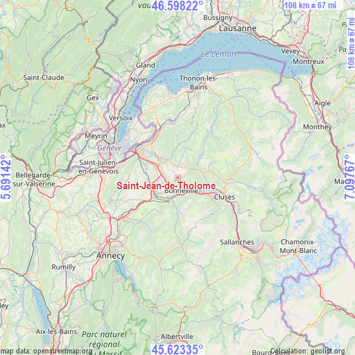
Saint-Jean-de-Tholome GPS coordinates[2]
46° 6' 46.584" North, 6° 23' 40.344" East
| Map corner | latitude | longitude |
|---|---|---|
| Upper-left | 46.59822°, | 5.69142° |
| Center: | 46.11294°, | 6.39454° |
| Lower-right: | 45.62335°, | 7.09767° |
| Map W x H: | 108.4×108.4 km | = 67.4×67.4mi |
| max Lat: | 51.07786° ⇑64.8% North |
| Saint-Jean-de-Tholome: | 46.11294° |
| min Lat: | ⇓35.2% South 41.3874° |
| min Long | Saint-Jean-de-T | max Long |
| -5.08615° | 6.39454° | 9.52242° |
| W 91%⇐ | ⇒9% E |
Elevation
Elevation of Saint-Jean-de-Tholome is 792 m = 2598 ft, and this is 598.3 m = 1963 ft above average elevation for this country.
| Max E: |
2333 m = 7654 ft | 2.3% |
| Saint-Jean-de-Tholome | 792 m 2598 ft | |
| Avg. | 193.7 m = 635 ft | |
Min E: |
-1 m = -3 ft | 97.7% |
See also: France elevation on elevation.city.
Geographical zone
Saint-Jean-de-Tholome is located in North temperate zone (between Tropic of Cancer and the Arctic Circle). Distance of this North polar circle is 2273.9 km =1412.9 mi to North.| Distance of | km | miles | from Saint-Jean-de-Tholome |
|---|---|---|---|
| North Pole | 4879.8 | 3032.2 | to North |
| Arctic Circle | 2273.9 | 1412.9 | to North |
| Tropic Cancer | 2521.4 | 1566.7 | to South |
| Equator | 5127.3 | 3186 | to South |


Nearby cities:
15 places around Saint-Jean-de-Tholome: (largest is in red/bold)
• Amancy
6.7 km =4.2 mi,  228°
228°
• Arenthon
4.8 km =3 mi,  262°
262°
• Ayse
5.3 km =3.3 mi,  131°
131°
• Bonneville
3.8 km =2.4 mi,  164°
164°
• Contamine-sur-Arve
5.8 km =3.6 mi,  304°
304°
• Cornier
7.7 km =4.8 mi,  253°
253°
• Fillinges
6.5 km =4 mi,  322°
322°
• La Tour
3.6 km =2.2 mi,  51°
51°
• Marcellaz
4.8 km =3 mi, 321°
• Peillonnex
2.2 km =1.4 mi, 322°
• Saint-Jeoire
5.8 km =3.6 mi,  62°
62°
• Scientrier
5.4 km =3.4 mi,  273°
273°
• Ville-en-Sallaz
4.1 km =2.5 mi,  30°
30°
• Viuz-en-Sallaz
3.9 km =2.4 mi,  15°
15°
• Vougy
7.8 km =4.8 mi, 130°
Sources, notices
• [Note1] Compared only with cities in France existing in our database
• [Src1] Map data: © OpenStreetMap contributors (CC-BY-SA)
• [Src2] Other city data from geonames.org with taken over terms of usage.
• [Src3] Geographical zone / Annual Mean Temperature by Robert A. Rohde @ Wikipedia
