Montils geodata
Montils (Nouvelle-Aquitaine) is a populated place; located in France in Europe/Paris (GMT+2) time zone. With population of 699 people, there are 11810 cities with bigger population in this country. Compared to other cities in France, 71.8% of cities are located further ↑North; 83.4% of cities are located further →East and 84.9% of cities have higher elevation than Montils. Note1
Administrative division(s):
- Level 1: Nouvelle-Aquitaine
- Level 2: Charente-Maritime
- Level 3: Arrondissement de Saintes
- Level 4: Montils


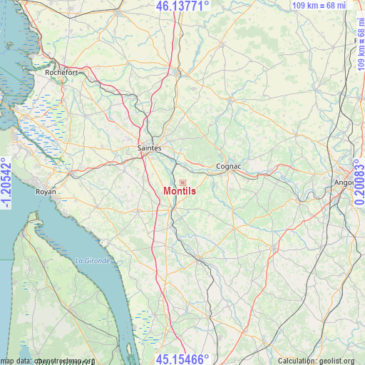
Montils GPS coordinates[2]
45° 38' 54.024" North, 0° 30' 8.28" West
| Map corner | latitude | longitude |
|---|---|---|
| Upper-left | 46.13771°, | -1.20542° |
| Center: | 45.64834°, | -0.5023° |
| Lower-right: | 45.15466°, | 0.20083° |
| Map W x H: | 109.3×109.3 km | = 67.9×67.9mi |
| max Lat: | 51.07786° ⇑71.8% North |
| Montils: | 45.64834° |
| min Lat: | ⇓28.2% South 41.3874° |
| min Long | Montils | max Long |
| -5.08615° | -0.5023° | 9.52242° |
| W 16.6%⇐ | ⇒83.4% E |
Elevation
Elevation of Montils is 42 m = 138 ft, and this is 151.7 m = 498 ft below average elevation for this country.
| Max E: |
2333 m = 7654 ft | 84.9% |
| Avg. | 193.7 m = 635 ft | |
| Montils | 42 m = 138 ft | |
Min E: |
-1 m = -3 ft | 15.1% |
See also: France elevation on elevation.city.
Geographical zone
Montils is located in North temperate zone (between Tropic of Cancer and the Arctic Circle). Distance of this North polar circle is 2325.6 km =1445.1 mi to North.| Distance of | km | miles | from Montils |
|---|---|---|---|
| North Pole | 4931.4 | 3064.2 | to North |
| Arctic Circle | 2325.6 | 1445.1 | to North |
| Tropic Cancer | 2469.7 | 1534.6 | to South |
| Equator | 5075.6 | 3153.8 | to South |


Nearby cities:
15 places around Montils: (largest is in red/bold)
• Ars
9.4 km =5.8 mi,  93°
93°
• Avy
10.6 km =6.6 mi,  182°
182°
• Chaniers
8.9 km =5.5 mi,  331°
331°
• Chérac
8 km =5 mi,  38°
38°
• Courcoury
9.2 km =5.7 mi,  319°
319°
• Gimeux
10.5 km =6.5 mi,  97°
97°
• Les Gonds
11.4 km =7.1 mi,  310°
310°
• Merpins
8.8 km =5.5 mi,  63°
63°
• Pons
8.4 km =5.2 mi,  204°
204°
• Pérignac
4 km =2.5 mi,  134°
134°
• Saint-Laurent-de-Cognac
9 km =5.6 mi,  53°
53°
• Saint-Léger
7 km =4.3 mi,  244°
244°
• Saint-Sauvant
10 km =6.2 mi,  358°
358°
• Saint-Sever-de-Saintonge
5.7 km =3.5 mi,  1°
1°
• Salignac-sur-Charente
6.2 km =3.9 mi,  65°
65°
Sources, notices
• [Note1] Compared only with cities in France existing in our database
• [Src1] Map data: © OpenStreetMap contributors (CC-BY-SA)
• [Src2] Other city data from geonames.org with taken over terms of usage.
• [Src3] Geographical zone / Annual Mean Temperature by Robert A. Rohde @ Wikipedia
