Augny geodata
Augny (Grand Est) is a populated place; located in France in Europe/Paris (GMT+2) time zone. With population of 2,615 people, there are 3730 cities with bigger population in this country. Compared to other cities in France, 81.1% of cities are located further ↓South; 88.4% of cities are located further ←West and 65% of cities have lower elevation than Augny. Note1
Administrative division(s):
- Level 1: Grand Est
- Level 2: Moselle
- Level 3: Arrondissement de Metz
- Level 4: Augny


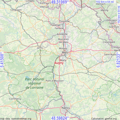
Augny GPS coordinates[2]
49° 3' 39.96" North, 6° 7' 5.52" East
| Map corner | latitude | longitude |
|---|---|---|
| Upper-left | 49.51969°, | 5.41508° |
| Center: | 49.0611°, | 6.1182° |
| Lower-right: | 48.59824°, | 6.82133° |
| Map W x H: | 102.5×102.5 km | = 63.7×63.7mi |
| max Lat: | 51.07786° ⇑18.9% North |
| Augny: | 49.0611° |
| min Lat: | ⇓81.1% South 41.3874° |
| min Long | Augny | max Long |
| -5.08615° | 6.1182° | 9.52242° |
| W 88.4%⇐ | ⇒11.6% E |
Elevation
Elevation of Augny is 194 m = 636 ft, and this is 0.30000000000001 m = 1 ft above average elevation for this country.
| Max E: |
2333 m = 7654 ft | 35% |
| Augny | 194 m 636 ft | |
| Avg. | 193.7 m = 635 ft | |
Min E: |
-1 m = -3 ft | 65% |
See also: France elevation on elevation.city.
Geographical zone
Augny is located in North temperate zone (between Tropic of Cancer and the Arctic Circle). Distance of this North polar circle is 1946.1 km =1209.3 mi to North.| Distance of | km | miles | from Augny |
|---|---|---|---|
| North Pole | 4552 | 2828.5 | to North |
| Arctic Circle | 1946.1 | 1209.3 | to North |
| Tropic Cancer | 2849.2 | 1770.4 | to South |
| Equator | 5455.1 | 3389.6 | to South |


Nearby cities:
15 places around Augny: (largest is in red/bold)
• Ancy-sur-Moselle
4.4 km =2.7 mi,  263°
263°
• Ars-sur-Moselle
3.7 km =2.3 mi,  300°
300°
• Coin-lès-Cuvry
4.1 km =2.5 mi,  137°
137°
• Corny-sur-Moselle
5.1 km =3.2 mi,  235°
235°
• Cuvry
3.6 km =2.2 mi,  124°
124°
• Féy
3.7 km =2.3 mi,  201°
201°
• Jouy-aux-Arches
2.8 km =1.7 mi,  270°
270°
• Marly
2.6 km =1.6 mi,  83°
83°
• Montigny-lès-Metz
4.6 km =2.9 mi,  33°
33°
• Moulins-lès-Metz
4.9 km =3 mi,  351°
351°
• Pouilly
5.1 km =3.2 mi,  104°
104°
• Pournoy-la-Chétive
5.3 km =3.3 mi,  150°
150°
• Rozérieulles
5.7 km =3.5 mi,  332°
332°
• Scy-Chazelles
5.8 km =3.6 mi,  357°
357°
• Vaux
4.2 km =2.6 mi, 327°
Sources, notices
• [Note1] Compared only with cities in France existing in our database
• [Src1] Map data: © OpenStreetMap contributors (CC-BY-SA)
• [Src2] Other city data from geonames.org with taken over terms of usage.
• [Src3] Geographical zone / Annual Mean Temperature by Robert A. Rohde @ Wikipedia
