Marly geodata
Marly (Grand Est) is a populated place; located in France in Europe/Paris (GMT+2) time zone. With population of 10,997 people, there are 872 cities with bigger population in this country. Compared to other cities in France, 81.2% of cities are located further ↓South; 88.9% of cities are located further ←West and 60.3% of cities have lower elevation than Marly. Note1
Administrative division(s):
- Level 1: Grand Est
- Level 2: Moselle
- Level 3: Arrondissement de Metz
- Level 4: Marly


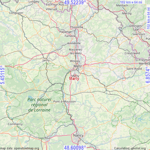
Marly GPS coordinates[2]
49° 3' 49.752" North, 6° 9' 15.372" East
| Map corner | latitude | longitude |
|---|---|---|
| Upper-left | 49.52239°, | 5.45115° |
| Center: | 49.06382°, | 6.15427° |
| Lower-right: | 48.60098°, | 6.8574° |
| Map W x H: | 102.5×102.4 km | = 63.7×63.6mi |
| max Lat: | 51.07786° ⇑18.8% North |
| Marly: | 49.06382° |
| min Lat: | ⇓81.2% South 41.3874° |
| min Long | Marly | max Long |
| -5.08615° | 6.15427° | 9.52242° |
| W 88.9%⇐ | ⇒11.1% E |
Elevation
Elevation of Marly is 171 m = 561 ft, and this is 22.7 m = 74 ft below average elevation for this country.
| Max E: |
2333 m = 7654 ft | 39.7% |
| Avg. | 193.7 m = 635 ft | |
| Marly | 171 m = 561 ft | |
Min E: |
-1 m = -3 ft | 60.3% |
See also: France elevation on elevation.city.
Geographical zone
Marly is located in North temperate zone (between Tropic of Cancer and the Arctic Circle). Distance of this North polar circle is 1945.8 km =1209.1 mi to North.| Distance of | km | miles | from Marly |
|---|---|---|---|
| North Pole | 4551.7 | 2828.3 | to North |
| Arctic Circle | 1945.8 | 1209.1 | to North |
| Tropic Cancer | 2849.5 | 1770.6 | to South |
| Equator | 5455.4 | 3389.8 | to South |


Nearby cities:
15 places around Marly: (largest is in red/bold)
• Ars-sur-Moselle
6 km =3.7 mi,  285°
285°
• Augny
2.6 km =1.6 mi,  263°
263°
• Coin-lès-Cuvry
3.3 km =2.1 mi,  177°
177°
• Cuvry
2.3 km =1.4 mi,  171°
171°
• Fleury
3.8 km =2.4 mi,  130°
130°
• Féy
5.5 km =3.4 mi,  226°
226°
• Jouy-aux-Arches
5.5 km =3.4 mi,  267°
267°
• Longeville-lès-Metz
5.7 km =3.5 mi,  346°
346°
• Montigny-lès-Metz
3.5 km =2.2 mi,  358°
358°
• Moulins-lès-Metz
5.6 km =3.5 mi,  323°
323°
• Peltre
5.5 km =3.4 mi,  77°
77°
• Pouilly
2.7 km =1.7 mi,  123°
123°
• Pournoy-la-Chétive
4.9 km =3 mi, 180°
• Scy-Chazelles
6.2 km =3.9 mi,  332°
332°
• Vaux
5.9 km =3.7 mi,  303°
303°
Sources, notices
• [Note1] Compared only with cities in France existing in our database
• [Src1] Map data: © OpenStreetMap contributors (CC-BY-SA)
• [Src2] Other city data from geonames.org with taken over terms of usage.
• [Src3] Geographical zone / Annual Mean Temperature by Robert A. Rohde @ Wikipedia
