Aubord geodata
Aubord (Occitanie) is a populated place; located in France in Europe/Paris (GMT+2) time zone. With population of 2,089 people, there are 4611 cities with bigger population in this country. Compared to other cities in France, 89.6% of cities are located further ↑North; 70.7% of cities are located further ←West and 93.1% of cities have higher elevation than Aubord. Note1
Administrative division(s):
- Level 1: Occitanie
- Level 2: Gard
- Level 3: Arrondissement de Nîmes
- Level 4: Aubord


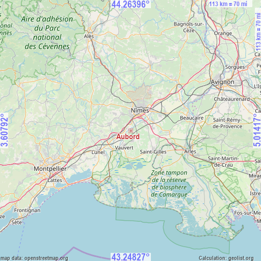
Aubord GPS coordinates[2]
43° 45' 29.772" North, 4° 18' 39.78" East
| Map corner | latitude | longitude |
|---|---|---|
| Upper-left | 44.26396°, | 3.60792° |
| Center: | 43.75827°, | 4.31105° |
| Lower-right: | 43.24827°, | 5.01417° |
| Map W x H: | 112.9×112.9 km | = 70.2×70.2mi |
| max Lat: | 51.07786° ⇑89.6% North |
| Aubord: | 43.75827° |
| min Lat: | ⇓10.4% South 41.3874° |
| min Long | Aubord | max Long |
| -5.08615° | 4.31105° | 9.52242° |
| W 70.7%⇐ | ⇒29.3% E |
Elevation
Elevation of Aubord is 22 m = 72 ft, and this is 171.7 m = 563 ft below average elevation for this country.
| Max E: |
2333 m = 7654 ft | 93.1% |
| Avg. | 193.7 m = 635 ft | |
| Aubord | 22 m = 72 ft | |
Min E: |
-1 m = -3 ft | 6.9% |
See also: France elevation on elevation.city.
Geographical zone
Aubord is located in North temperate zone (between Tropic of Cancer and the Arctic Circle). Distance of this Northern Tropic circle is 2259.5 km =1404 mi to South.| Distance of | km | miles | from Aubord |
|---|---|---|---|
| North Pole | 5141.6 | 3194.8 | to North |
| Arctic Circle | 2535.7 | 1575.6 | to North |
| Tropic Cancer | 2259.5 | 1404 | to South |
| Equator | 4865.5 | 3023.3 | to South |


Nearby cities:
15 places around Aubord: (largest is in red/bold)
• Beauvoisin
4.5 km =2.8 mi,  167°
167°
• Bernis
2.3 km =1.4 mi,  302°
302°
• Boissières
6.6 km =4.1 mi,  285°
285°
• Caissargues
6.9 km =4.3 mi,  53°
53°
• Caveirac
8.2 km =5.1 mi,  334°
334°
• Codognan
7.9 km =4.9 mi,  246°
246°
• Générac
4.6 km =2.9 mi,  136°
136°
• Langlade
6.8 km =4.2 mi,  316°
316°
• Milhaud
3.5 km =2.2 mi,  359°
359°
• Nages-et-Solorgues
7.4 km =4.6 mi, 298°
• Saint-Dionisy
7.8 km =4.8 mi,  306°
306°
• Uchaud
3.4 km =2.1 mi,  270°
270°
• Vauvert
7.5 km =4.7 mi,  201°
201°
• Vergèze
7.4 km =4.6 mi,  257°
257°
• Vestric-et-Candiac
4.6 km =2.9 mi,  244°
244°
Sources, notices
• [Note1] Compared only with cities in France existing in our database
• [Src1] Map data: © OpenStreetMap contributors (CC-BY-SA)
• [Src2] Other city data from geonames.org with taken over terms of usage.
• [Src3] Geographical zone / Annual Mean Temperature by Robert A. Rohde @ Wikipedia
