Générac geodata
Générac (Occitanie) is a populated place; located in France in Europe/Paris (GMT+2) time zone. With population of 3,488 people, there are 2789 cities with bigger population in this country. Compared to other cities in France, 90% of cities are located further ↑North; 71% of cities are located further ←West and 67.4% of cities have higher elevation than Générac. Note1
Administrative division(s):
- Level 1: Occitanie
- Level 2: Gard
- Level 3: Arrondissement de Nîmes
- Level 4: Générac


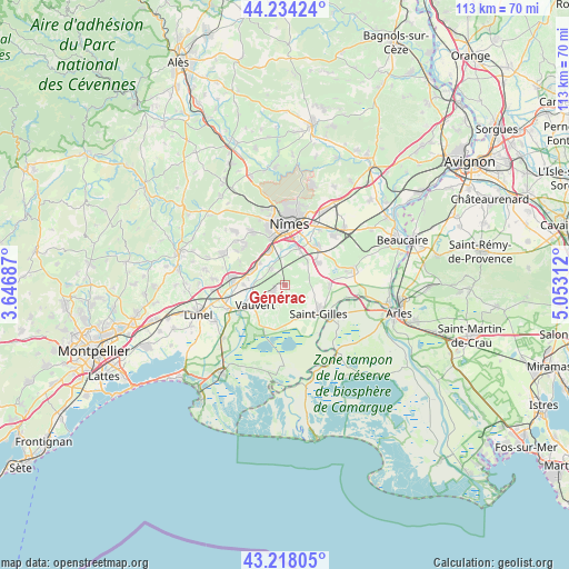
Générac GPS coordinates[2]
43° 43' 41.88" North, 4° 21' 0" East
| Map corner | latitude | longitude |
|---|---|---|
| Upper-left | 44.23424°, | 3.64687° |
| Center: | 43.7283°, | 4.35° |
| Lower-right: | 43.21805°, | 5.05312° |
| Map W x H: | 113×113 km | = 70.2×70.2mi |
| max Lat: | 51.07786° ⇑90% North |
| Générac: | 43.7283° |
| min Lat: | ⇓10% South 41.3874° |
| min Long | Générac | max Long |
| -5.08615° | 4.35° | 9.52242° |
| W 71%⇐ | ⇒29% E |
Elevation
Elevation of Générac is 84 m = 276 ft, and this is 109.7 m = 360 ft below average elevation for this country.
| Max E: |
2333 m = 7654 ft | 67.4% |
| Avg. | 193.7 m = 635 ft | |
| Générac | 84 m = 276 ft | |
Min E: |
-1 m = -3 ft | 32.6% |
See also: France elevation on elevation.city.
Geographical zone
Générac is located in North temperate zone (between Tropic of Cancer and the Arctic Circle). Distance of this Northern Tropic circle is 2256.2 km =1401.9 mi to South.| Distance of | km | miles | from Générac |
|---|---|---|---|
| North Pole | 5144.9 | 3196.9 | to North |
| Arctic Circle | 2539 | 1577.7 | to North |
| Tropic Cancer | 2256.2 | 1401.9 | to South |
| Equator | 4862.1 | 3021.2 | to South |


Nearby cities:
15 places around Générac: (largest is in red/bold)
• Aubord
4.6 km =2.9 mi,  316°
316°
• Beauvoisin
2.4 km =1.5 mi,  242°
242°
• Bernis
6.8 km =4.2 mi,  311°
311°
• Boissières
10.8 km =6.7 mi,  298°
298°
• Bouillargues
9.9 km =6.2 mi,  39°
39°
• Caissargues
7.8 km =4.8 mi,  17°
17°
• Codognan
10.4 km =6.5 mi,  271°
271°
• Garons
7.7 km =4.8 mi,  54°
54°
• Le Cailar
10.7 km =6.6 mi, 239°
• Milhaud
7.5 km =4.7 mi,  335°
335°
• Saint-Gilles
8.6 km =5.3 mi,  131°
131°
• Uchaud
7.4 km =4.6 mi, 297°
• Vauvert
6.9 km =4.3 mi, 237°
• Vergèze
10.5 km =6.5 mi,  279°
279°
• Vestric-et-Candiac
7.4 km =4.6 mi, 280°
Sources, notices
• [Note1] Compared only with cities in France existing in our database
• [Src1] Map data: © OpenStreetMap contributors (CC-BY-SA)
• [Src2] Other city data from geonames.org with taken over terms of usage.
• [Src3] Geographical zone / Annual Mean Temperature by Robert A. Rohde @ Wikipedia
