Caissargues geodata
Caissargues (Occitanie) is a populated place; located in France in Europe/Paris (GMT+2) time zone. With population of 3,858 people, there are 2550 cities with bigger population in this country. Compared to other cities in France, 89.2% of cities are located further ↑North; 71.3% of cities are located further ←West and 89.5% of cities have higher elevation than Caissargues. Note1
Administrative division(s):
- Level 1: Occitanie
- Level 2: Gard
- Level 3: Arrondissement de Nîmes
- Level 4: Caissargues


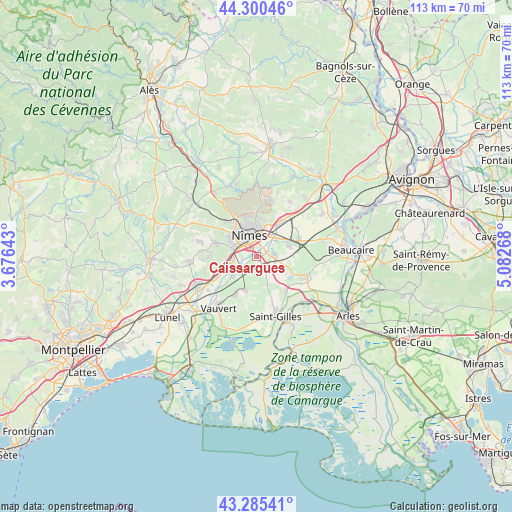
Caissargues GPS coordinates[2]
43° 47' 42.324" North, 4° 22' 46.38" East
| Map corner | latitude | longitude |
|---|---|---|
| Upper-left | 44.30046°, | 3.67643° |
| Center: | 43.79509°, | 4.37955° |
| Lower-right: | 43.28541°, | 5.08268° |
| Map W x H: | 112.9×112.9 km | = 70.2×70.2mi |
| max Lat: | 51.07786° ⇑89.2% North |
| Caissargues: | 43.79509° |
| min Lat: | ⇓10.8% South 41.3874° |
| min Long | Caissargues | max Long |
| -5.08615° | 4.37955° | 9.52242° |
| W 71.3%⇐ | ⇒28.7% E |
Elevation
Elevation of Caissargues is 31 m = 102 ft, and this is 162.7 m = 534 ft below average elevation for this country.
| Max E: |
2333 m = 7654 ft | 89.5% |
| Avg. | 193.7 m = 635 ft | |
| Caissargues | 31 m = 102 ft | |
Min E: |
-1 m = -3 ft | 10.5% |
See also: France elevation on elevation.city.
Geographical zone
Caissargues is located in North temperate zone (between Tropic of Cancer and the Arctic Circle). Distance of this Northern Tropic circle is 2263.6 km =1406.5 mi to South.| Distance of | km | miles | from Caissargues |
|---|---|---|---|
| North Pole | 5137.5 | 3192.3 | to North |
| Arctic Circle | 2531.6 | 1573.1 | to North |
| Tropic Cancer | 2263.6 | 1406.5 | to South |
| Equator | 4869.6 | 3025.8 | to South |


Nearby cities:
15 places around Caissargues: (largest is in red/bold)
• Aubord
6.9 km =4.3 mi,  233°
233°
• Beauvoisin
9.7 km =6 mi,  207°
207°
• Bernis
8 km =5 mi,  248°
248°
• Bouillargues
3.9 km =2.4 mi,  86°
86°
• Caveirac
9.6 km =6 mi,  289°
289°
• Garons
4.8 km =3 mi,  127°
127°
• Générac
7.8 km =4.8 mi,  197°
197°
• Langlade
10.2 km =6.3 mi,  274°
274°
• Manduel
7.9 km =4.9 mi,  70°
70°
• Marguerittes
8.9 km =5.5 mi,  36°
36°
• Milhaud
5.6 km =3.5 mi,  263°
263°
• Nîmes
4.6 km =2.9 mi,  339°
339°
• Redessan
10.3 km =6.4 mi, 67°
• Rodilhan
5.5 km =3.4 mi,  49°
49°
• Uchaud
9.8 km =6.1 mi, 245°
Sources, notices
• [Note1] Compared only with cities in France existing in our database
• [Src1] Map data: © OpenStreetMap contributors (CC-BY-SA)
• [Src2] Other city data from geonames.org with taken over terms of usage.
• [Src3] Geographical zone / Annual Mean Temperature by Robert A. Rohde @ Wikipedia
