Marly geodata
Marly (Hauts-de-France) is a populated place; located in France in Europe/Paris (GMT+2) time zone. With population of 11,681 people, there are 822 cities with bigger population in this country. Compared to other cities in France, 95.9% of cities are located further ↓South; 64.7% of cities are located further ←West and 84.9% of cities have higher elevation than Marly. Note1
Administrative division(s):
- Level 1: Hauts-de-France
- Level 2: Nord
- Level 3: Arrondissement de Valenciennes
- Level 4: Marly


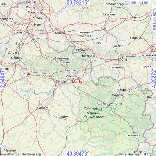
Marly GPS coordinates[2]
50° 20' 44.016" North, 3° 32' 58.524" East
| Map corner | latitude | longitude |
|---|---|---|
| Upper-left | 50.79215°, | 2.84647° |
| Center: | 50.34556°, | 3.54959° |
| Lower-right: | 49.89473°, | 4.25272° |
| Map W x H: | 99.8×99.8 km | = 62×62mi |
| max Lat: | 51.07786° ⇑4.1% North |
| Marly: | 50.34556° |
| min Lat: | ⇓95.9% South 41.3874° |
| min Long | Marly | max Long |
| -5.08615° | 3.54959° | 9.52242° |
| W 64.7%⇐ | ⇒35.3% E |
Elevation
Elevation of Marly is 42 m = 138 ft, and this is 151.7 m = 498 ft below average elevation for this country.
| Max E: |
2333 m = 7654 ft | 84.9% |
| Avg. | 193.7 m = 635 ft | |
| Marly | 42 m = 138 ft | |
Min E: |
-1 m = -3 ft | 15.1% |
See also: France elevation on elevation.city.
Geographical zone
Marly is located in North temperate zone (between Tropic of Cancer and the Arctic Circle). Distance of this North polar circle is 1803.3 km =1120.5 mi to North.| Distance of | km | miles | from Marly |
|---|---|---|---|
| North Pole | 4409.2 | 2739.7 | to North |
| Arctic Circle | 1803.3 | 1120.5 | to North |
| Tropic Cancer | 2992 | 1859.1 | to South |
| Equator | 5597.9 | 3478.4 | to South |


Nearby cities:
15 places around Marly: (largest is in red/bold)
• Anzin
4.4 km =2.7 mi,  312°
312°
• Artres
5.7 km =3.5 mi,  186°
186°
• Aulnoy-lez-Valenciennes
1.8 km =1.1 mi,  220°
220°
• Beuvrages
5.8 km =3.6 mi,  317°
317°
• Curgies
4.2 km =2.6 mi,  114°
114°
• Estreux
3.2 km =2 mi,  78°
78°
• Famars
3.8 km =2.4 mi,  214°
214°
• La Sentinelle
4.7 km =2.9 mi,  277°
277°
• Onnaing
5.7 km =3.5 mi,  38°
38°
• Petite-Forêt
5.3 km =3.3 mi,  296°
296°
• Préseau
4.2 km =2.6 mi,  155°
155°
• Saint-Saulve
2.9 km =1.8 mi,  9°
9°
• Saultain
2.2 km =1.4 mi,  116°
116°
• Trith-Saint-Léger
5.7 km =3.5 mi,  235°
235°
• Valenciennes
2.3 km =1.4 mi, 310°
Sources, notices
• [Note1] Compared only with cities in France existing in our database
• [Src1] Map data: © OpenStreetMap contributors (CC-BY-SA)
• [Src2] Other city data from geonames.org with taken over terms of usage.
• [Src3] Geographical zone / Annual Mean Temperature by Robert A. Rohde @ Wikipedia
