Arpajon geodata
Arpajon (Île-de-France) is a populated place; located in France in Europe/Paris (GMT+2) time zone. With population of 9,742 people, there are 977 cities with bigger population in this country. Compared to other cities in France, 70.6% of cities are located further ↓South; 53.6% of cities are located further →East and 81.8% of cities have higher elevation than Arpajon. Note1
Administrative division(s):
- Level 1: Île-de-France
- Level 2: Département de l'Essonne
- Level 3: Arrondissement de Palaiseau
- Level 4: Arpajon


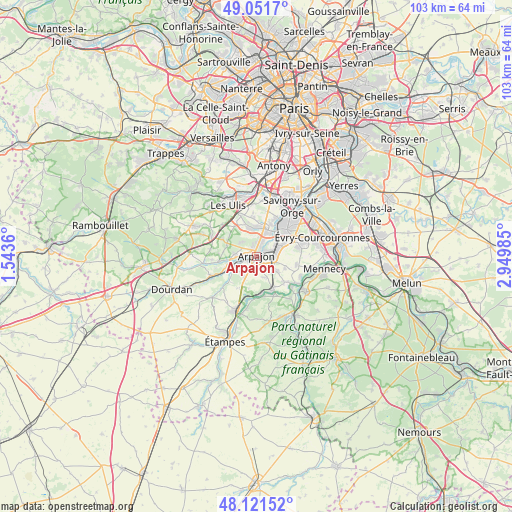
Arpajon GPS coordinates[2]
48° 35' 19.5" North, 2° 14' 48.192" East
| Map corner | latitude | longitude |
|---|---|---|
| Upper-left | 49.0517°, | 1.5436° |
| Center: | 48.58875°, | 2.24672° |
| Lower-right: | 48.12152°, | 2.94985° |
| Map W x H: | 103.4×103.4 km | = 64.2×64.2mi |
| max Lat: | 51.07786° ⇑29.4% North |
| Arpajon: | 48.58875° |
| min Lat: | ⇓70.6% South 41.3874° |
| min Long | Arpajon | max Long |
| -5.08615° | 2.24672° | 9.52242° |
| W 46.4%⇐ | ⇒53.6% E |
Elevation
Elevation of Arpajon is 50 m = 164 ft, and this is 143.7 m = 471 ft below average elevation for this country.
| Max E: |
2333 m = 7654 ft | 81.8% |
| Avg. | 193.7 m = 635 ft | |
| Arpajon | 50 m = 164 ft | |
Min E: |
-1 m = -3 ft | 18.2% |
See also: France elevation on elevation.city.
Geographical zone
Arpajon is located in North temperate zone (between Tropic of Cancer and the Arctic Circle). Distance of this North polar circle is 1998.6 km =1241.9 mi to North.| Distance of | km | miles | from Arpajon |
|---|---|---|---|
| North Pole | 4604.5 | 2861.1 | to North |
| Arctic Circle | 1998.6 | 1241.9 | to North |
| Tropic Cancer | 2796.6 | 1737.7 | to South |
| Equator | 5402.6 | 3357 | to South |


Nearby cities:
15 places around Arpajon: (largest is in red/bold)
• Avrainville
2.9 km =1.8 mi,  181°
181°
• Boissy-sous-Saint-Yon
4.6 km =2.9 mi,  213°
213°
• Breuillet
5.7 km =3.5 mi,  249°
249°
• Bruyères-le-Châtel
4.2 km =2.6 mi,  269°
269°
• Brétigny-sur-Orge
5 km =3.1 mi,  60°
60°
• Cheptainville
4.7 km =2.9 mi,  152°
152°
• Guibeville
2.7 km =1.7 mi,  138°
138°
• La Norville
1.3 km =0.8 mi,  122°
122°
• Leuville-sur-Orge
3.5 km =2.2 mi,  24°
24°
• Linas
4.8 km =3 mi,  14°
14°
• Marolles-en-Hurepoix
4.8 km =3 mi,  127°
127°
• Ollainville
2 km =1.2 mi,  276°
276°
• Saint-Germain-lès-Arpajon
1.6 km =1 mi,  54°
54°
• Saint-Yon
5.3 km =3.3 mi,  230°
230°
• Égly
2 km =1.2 mi, 234°
Sources, notices
• [Note1] Compared only with cities in France existing in our database
• [Src1] Map data: © OpenStreetMap contributors (CC-BY-SA)
• [Src2] Other city data from geonames.org with taken over terms of usage.
• [Src3] Geographical zone / Annual Mean Temperature by Robert A. Rohde @ Wikipedia
