Breuillet geodata
Breuillet (Île-de-France) is a populated place; located in France in Europe/Paris (GMT+2) time zone. With population of 7,755 people, there are 1248 cities with bigger population in this country. Compared to other cities in France, 70.1% of cities are located further ↓South; 54.8% of cities are located further →East and 64% of cities have higher elevation than Breuillet. Note1
Administrative division(s):
- Level 1: Île-de-France
- Level 2: Département de l'Essonne
- Level 3: Arrondissement de Palaiseau
- Level 4: Breuillet


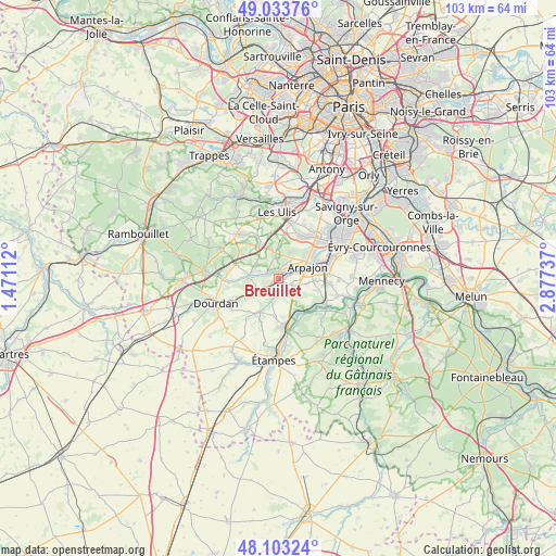
Breuillet GPS coordinates[2]
48° 34' 14.304" North, 2° 10' 27.264" East
| Map corner | latitude | longitude |
|---|---|---|
| Upper-left | 49.03376°, | 1.47112° |
| Center: | 48.57064°, | 2.17424° |
| Lower-right: | 48.10324°, | 2.87737° |
| Map W x H: | 103.5×103.5 km | = 64.3×64.3mi |
| max Lat: | 51.07786° ⇑29.9% North |
| Breuillet: | 48.57064° |
| min Lat: | ⇓70.1% South 41.3874° |
| min Long | Breuillet | max Long |
| -5.08615° | 2.17424° | 9.52242° |
| W 45.2%⇐ | ⇒54.8% E |
Elevation
Elevation of Breuillet is 92 m = 302 ft, and this is 101.7 m = 334 ft below average elevation for this country.
| Max E: |
2333 m = 7654 ft | 64% |
| Avg. | 193.7 m = 635 ft | |
| Breuillet | 92 m = 302 ft | |
Min E: |
-1 m = -3 ft | 36% |
See also: France elevation on elevation.city.
Geographical zone
Breuillet is located in North temperate zone (between Tropic of Cancer and the Arctic Circle). Distance of this North polar circle is 2000.6 km =1243.1 mi to North.| Distance of | km | miles | from Breuillet |
|---|---|---|---|
| North Pole | 4606.5 | 2862.3 | to North |
| Arctic Circle | 2000.6 | 1243.1 | to North |
| Tropic Cancer | 2794.6 | 1736.5 | to South |
| Equator | 5400.5 | 3355.7 | to South |


Nearby cities:
15 places around Breuillet: (largest is in red/bold)
• Arpajon
5.7 km =3.5 mi,  69°
69°
• Avrainville
5.3 km =3.3 mi,  99°
99°
• Boissy-sous-Saint-Yon
3.4 km =2.1 mi,  123°
123°
• Bruyères-le-Châtel
2.3 km =1.4 mi,  29°
29°
• Chamarande
6.7 km =4.2 mi,  152°
152°
• Courson-Monteloup
3.8 km =2.4 mi,  331°
331°
• Fontenay-lès-Briis
5.7 km =3.5 mi,  343°
343°
• Guibeville
7.1 km =4.4 mi,  90°
90°
• La Norville
6.6 km =4.1 mi,  78°
78°
• Ollainville
4 km =2.5 mi,  55°
55°
• Saint-Chéron
4.1 km =2.5 mi,  243°
243°
• Saint-Maurice-Montcouronne
3.9 km =2.4 mi,  290°
290°
• Saint-Yon
1.9 km =1.2 mi,  138°
138°
• Vaugrigneuse
5.2 km =3.2 mi,  312°
312°
• Égly
3.8 km =2.4 mi, 76°
Sources, notices
• [Note1] Compared only with cities in France existing in our database
• [Src1] Map data: © OpenStreetMap contributors (CC-BY-SA)
• [Src2] Other city data from geonames.org with taken over terms of usage.
• [Src3] Geographical zone / Annual Mean Temperature by Robert A. Rohde @ Wikipedia
