Ardoix geodata
Ardoix (Auvergne-Rhône-Alpes) is a populated place; located in France in Europe/Paris (GMT+2) time zone. With population of 817 people, there are 10416 cities with bigger population in this country. Compared to other cities in France, 77.6% of cities are located further ↑North; 74.2% of cities are located further ←West and 81% of cities have lower elevation than Ardoix. Note1
Administrative division(s):
- Level 1: Auvergne-Rhône-Alpes
- Level 2: Département de l'Ardèche
- Level 3: Arrondissement de Tournon-sur-Rhône
- Level 4: Ardoix


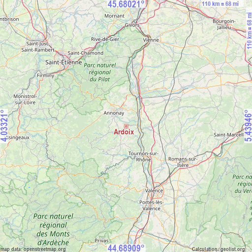
Ardoix GPS coordinates[2]
45° 11' 12.516" North, 4° 44' 10.788" East
| Map corner | latitude | longitude |
|---|---|---|
| Upper-left | 45.68021°, | 4.03321° |
| Center: | 45.18681°, | 4.73633° |
| Lower-right: | 44.68909°, | 5.43946° |
| Map W x H: | 110.2×110.2 km | = 68.5×68.5mi |
| max Lat: | 51.07786° ⇑77.6% North |
| Ardoix: | 45.18681° |
| min Lat: | ⇓22.4% South 41.3874° |
| min Long | Ardoix | max Long |
| -5.08615° | 4.73633° | 9.52242° |
| W 74.2%⇐ | ⇒25.8% E |
Elevation
Elevation of Ardoix is 300 m = 984 ft, and this is 106.3 m = 349 ft above average elevation for this country.
| Max E: |
2333 m = 7654 ft | 19% |
| Ardoix | 300 m 984 ft | |
| Avg. | 193.7 m = 635 ft | |
Min E: |
-1 m = -3 ft | 81% |
See also: France elevation on elevation.city.
Geographical zone
Ardoix is located in North temperate zone (between Tropic of Cancer and the Arctic Circle). Distance of this North polar circle is 2376.9 km =1476.9 mi to North.| Distance of | km | miles | from Ardoix |
|---|---|---|---|
| North Pole | 4982.8 | 3096.2 | to North |
| Arctic Circle | 2376.9 | 1476.9 | to North |
| Tropic Cancer | 2418.4 | 1502.7 | to South |
| Equator | 5024.3 | 3122 | to South |


Nearby cities:
15 places around Ardoix: (largest is in red/bold)
• Andance
7.7 km =4.8 mi,  39°
39°
• Annonay
7.8 km =4.8 mi,  318°
318°
• Beausemblant
8.2 km =5.1 mi,  65°
65°
• Davézieux
7.9 km =4.9 mi,  343°
343°
• Eclassan
3.7 km =2.3 mi,  148°
148°
• Laveyron
7.1 km =4.4 mi, 68°
• Quintenas
3.8 km =2.4 mi,  273°
273°
• Roiffieux
7.8 km =4.8 mi,  304°
304°
• Saint-Cyr
7.2 km =4.5 mi,  356°
356°
• Saint-Désirat
8.6 km =5.3 mi,  26°
26°
• Saint-Vallier
6.6 km =4.1 mi,  104°
104°
• Sarras
5 km =3.1 mi,  90°
90°
• Serves-sur-Rhône
8.6 km =5.3 mi,  132°
132°
• Talencieux
5 km =3.1 mi, 40°
• Vernosc-lès-Annonay
3.7 km =2.3 mi,  330°
330°
Sources, notices
• [Note1] Compared only with cities in France existing in our database
• [Src1] Map data: © OpenStreetMap contributors (CC-BY-SA)
• [Src2] Other city data from geonames.org with taken over terms of usage.
• [Src3] Geographical zone / Annual Mean Temperature by Robert A. Rohde @ Wikipedia
