Serves-sur-Rhône geodata
Serves-sur-Rhône (Auvergne-Rhône-Alpes) is a populated place; located in France in Europe/Paris (GMT+2) time zone. With population of 582 people, there are 13612 cities with bigger population in this country. Compared to other cities in France, 78.1% of cities are located further ↑North; 75.3% of cities are located further ←West and 85.4% of cities have lower elevation than Serves-sur-Rhône. Note1
Administrative division(s):
- Level 1: Auvergne-Rhône-Alpes
- Level 2: Département de la Drôme
- Level 3: Arrondissement de Valence
- Level 4: Serves-sur-Rhône


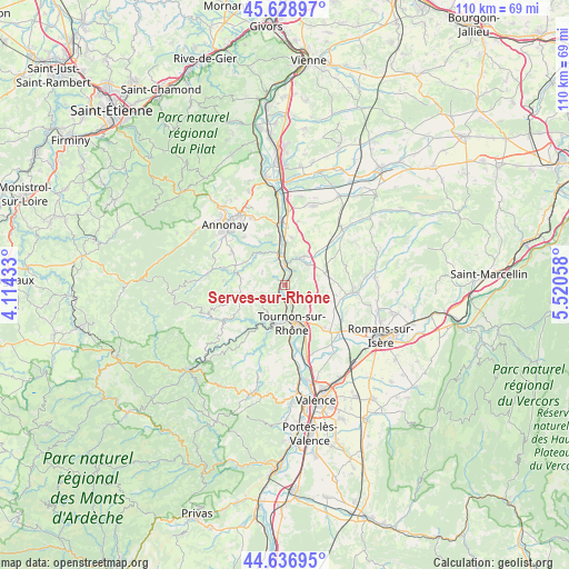
Serves-sur-Rhône GPS coordinates[2]
45° 8' 6.432" North, 4° 49' 2.856" East
| Map corner | latitude | longitude |
|---|---|---|
| Upper-left | 45.62897°, | 4.11433° |
| Center: | 45.13512°, | 4.81746° |
| Lower-right: | 44.63695°, | 5.52058° |
| Map W x H: | 110.3×110.3 km | = 68.5×68.5mi |
| max Lat: | 51.07786° ⇑78.1% North |
| Serves-sur-Rhône: | 45.13512° |
| min Lat: | ⇓21.9% South 41.3874° |
| min Long | Serves-sur-Rhô | max Long |
| -5.08615° | 4.81746° | 9.52242° |
| W 75.3%⇐ | ⇒24.7% E |
Elevation
Elevation of Serves-sur-Rhône is 351 m = 1152 ft, and this is 157.3 m = 516 ft above average elevation for this country.
| Max E: |
2333 m = 7654 ft | 14.6% |
| Serves-sur-Rhône | 351 m 1152 ft | |
| Avg. | 193.7 m = 635 ft | |
Min E: |
-1 m = -3 ft | 85.4% |
See also: France elevation on elevation.city.
Geographical zone
Serves-sur-Rhône is located in North temperate zone (between Tropic of Cancer and the Arctic Circle). Distance of this North polar circle is 2382.6 km =1480.5 mi to North.| Distance of | km | miles | from Serves-sur-Rhône |
|---|---|---|---|
| North Pole | 4988.5 | 3099.7 | to North |
| Arctic Circle | 2382.6 | 1480.5 | to North |
| Tropic Cancer | 2412.6 | 1499.1 | to South |
| Equator | 5018.6 | 3118.4 | to South |


Nearby cities:
15 places around Serves-sur-Rhône: (largest is in red/bold)
• Chantemerle-les-Blés
6.5 km =4 mi,  109°
109°
• Eclassan
5.1 km =3.2 mi,  300°
300°
• Larnage
5.6 km =3.5 mi,  139°
139°
• Laveyron
8.3 km =5.2 mi,  1°
1°
• Lemps
5 km =3.1 mi,  235°
235°
• Saint-Barthélemy-de-Vals
5.7 km =3.5 mi,  48°
48°
• Saint-Jean-de-Muzols
5.9 km =3.7 mi,  182°
182°
• Saint-Uze
6.4 km =4 mi,  31°
31°
• Saint-Vallier
4 km =2.5 mi, 0°
• Sarras
5.9 km =3.7 mi,  346°
346°
• Tain-l’Hermitage
8.2 km =5.1 mi,  158°
158°
• Tournon-sur-Rhône
7.7 km =4.8 mi,  170°
170°
• Vion
2.9 km =1.8 mi,  196°
196°
• Érôme
1.6 km =1 mi, 172°
• Étables
8.2 km =5.1 mi, 242°
Sources, notices
• [Note1] Compared only with cities in France existing in our database
• [Src1] Map data: © OpenStreetMap contributors (CC-BY-SA)
• [Src2] Other city data from geonames.org with taken over terms of usage.
• [Src3] Geographical zone / Annual Mean Temperature by Robert A. Rohde @ Wikipedia
