Beausemblant geodata
Beausemblant (Auvergne-Rhône-Alpes) is a populated place; located in France in Europe/Paris (GMT+2) time zone. With population of 1,246 people, there are 7305 cities with bigger population in this country. Compared to other cities in France, 77.3% of cities are located further ↑North; 75.5% of cities are located further ←West and 57.4% of cities have lower elevation than Beausemblant. Note1
Administrative division(s):
- Level 1: Auvergne-Rhône-Alpes
- Level 2: Département de la Drôme
- Level 3: Arrondissement de Valence
- Level 4: Beausemblant


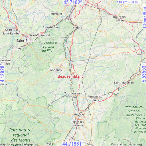
Beausemblant GPS coordinates[2]
45° 13' 1.416" North, 4° 49' 56.676" East
| Map corner | latitude | longitude |
|---|---|---|
| Upper-left | 45.7102°, | 4.12928° |
| Center: | 45.21706°, | 4.83241° |
| Lower-right: | 44.71961°, | 5.53553° |
| Map W x H: | 110.1×110.1 km | = 68.4×68.4mi |
| max Lat: | 51.07786° ⇑77.3% North |
| Beausemblant: | 45.21706° |
| min Lat: | ⇓22.7% South 41.3874° |
| min Long | Beausemblant | max Long |
| -5.08615° | 4.83241° | 9.52242° |
| W 75.5%⇐ | ⇒24.5% E |
Elevation
Elevation of Beausemblant is 159 m = 522 ft, and this is 34.7 m = 114 ft below average elevation for this country.
| Max E: |
2333 m = 7654 ft | 42.6% |
| Avg. | 193.7 m = 635 ft | |
| Beausemblant | 159 m = 522 ft | |
Min E: |
-1 m = -3 ft | 57.4% |
See also: France elevation on elevation.city.
Geographical zone
Beausemblant is located in North temperate zone (between Tropic of Cancer and the Arctic Circle). Distance of this North polar circle is 2373.5 km =1474.8 mi to North.| Distance of | km | miles | from Beausemblant |
|---|---|---|---|
| North Pole | 4979.4 | 3094.1 | to North |
| Arctic Circle | 2373.5 | 1474.8 | to North |
| Tropic Cancer | 2421.7 | 1504.8 | to South |
| Equator | 5027.7 | 3124.1 | to South |


Nearby cities:
15 places around Beausemblant: (largest is in red/bold)
• Andance
3.7 km =2.3 mi,  315°
315°
• Andancette
4 km =2.5 mi,  331°
331°
• Anneyron
7.4 km =4.6 mi,  34°
34°
• Ardoix
8.2 km =5.1 mi,  245°
245°
• Champagne
6.7 km =4.2 mi,  338°
338°
• Claveyson
8.8 km =5.5 mi,  118°
118°
• Eclassan
8.6 km =5.3 mi,  220°
220°
• La Motte-de-Galaure
6.3 km =3.9 mi,  110°
110°
• Laveyron
1.2 km =0.7 mi,  230°
230°
• Saint-Barthélemy-de-Vals
6.1 km =3.8 mi,  149°
149°
• Saint-Désirat
5.7 km =3.5 mi, 319°
• Saint-Uze
4.3 km =2.7 mi, 149°
• Saint-Vallier
5.2 km =3.2 mi,  192°
192°
• Sarras
4.2 km =2.6 mi, 216°
• Talencieux
4.3 km =2.7 mi,  276°
276°
Sources, notices
• [Note1] Compared only with cities in France existing in our database
• [Src1] Map data: © OpenStreetMap contributors (CC-BY-SA)
• [Src2] Other city data from geonames.org with taken over terms of usage.
• [Src3] Geographical zone / Annual Mean Temperature by Robert A. Rohde @ Wikipedia
