Andancette geodata
Andancette (Auvergne-Rhône-Alpes) is a populated place; located in France in Europe/Paris (GMT+2) time zone. With population of 1,229 people, there are 7384 cities with bigger population in this country. Compared to other cities in France, 76.9% of cities are located further ↑North; 75.2% of cities are located further ←West and 54.2% of cities have lower elevation than Andancette. Note1
Administrative division(s):
- Level 1: Auvergne-Rhône-Alpes
- Level 2: Département de la Drôme
- Level 3: Arrondissement de Valence
- Level 4: Andancette


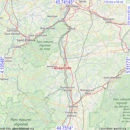
Andancette GPS coordinates[2]
45° 14' 54.888" North, 4° 48' 30.96" East
| Map corner | latitude | longitude |
|---|---|---|
| Upper-left | 45.74145°, | 4.10548° |
| Center: | 45.24858°, | 4.8086° |
| Lower-right: | 44.7514°, | 5.51173° |
| Map W x H: | 110.1×110.1 km | = 68.4×68.4mi |
| max Lat: | 51.07786° ⇑76.9% North |
| Andancette: | 45.24858° |
| min Lat: | ⇓23.1% South 41.3874° |
| min Long | Andancette | max Long |
| -5.08615° | 4.8086° | 9.52242° |
| W 75.2%⇐ | ⇒24.8% E |
Elevation
Elevation of Andancette is 147 m = 482 ft, and this is 46.7 m = 153 ft below average elevation for this country.
| Max E: |
2333 m = 7654 ft | 45.8% |
| Avg. | 193.7 m = 635 ft | |
| Andancette | 147 m = 482 ft | |
Min E: |
-1 m = -3 ft | 54.2% |
See also: France elevation on elevation.city.
Geographical zone
Andancette is located in North temperate zone (between Tropic of Cancer and the Arctic Circle). Distance of this North polar circle is 2370 km =1472.6 mi to North.| Distance of | km | miles | from Andancette |
|---|---|---|---|
| North Pole | 4975.9 | 3091.9 | to North |
| Arctic Circle | 2370 | 1472.6 | to North |
| Tropic Cancer | 2425.3 | 1507 | to South |
| Equator | 5031.2 | 3126.2 | to South |


Nearby cities:
15 places around Andancette: (largest is in red/bold)
• Andance
1.2 km =0.7 mi,  219°
219°
• Anneyron
6.6 km =4.1 mi,  66°
66°
• Beausemblant
4 km =2.5 mi,  151°
151°
• Champagne
2.8 km =1.7 mi,  346°
346°
• Chanas
7.8 km =4.8 mi,  5°
5°
• Davézieux
8 km =5 mi,  275°
275°
• Laveyron
4.4 km =2.7 mi,  167°
167°
• Peaugres
7.6 km =4.7 mi,  303°
303°
• Saint-Cyr
6.1 km =3.8 mi,  273°
273°
• Saint-Désirat
2 km =1.2 mi,  294°
294°
• Saint-Uze
8.2 km =5.1 mi, 150°
• Sarras
6.9 km =4.3 mi,  185°
185°
• Serrières
8.5 km =5.3 mi,  335°
335°
• Talencieux
3.9 km =2.4 mi, 218°
• Vernosc-lès-Annonay
8.3 km =5.2 mi,  244°
244°
Sources, notices
• [Note1] Compared only with cities in France existing in our database
• [Src1] Map data: © OpenStreetMap contributors (CC-BY-SA)
• [Src2] Other city data from geonames.org with taken over terms of usage.
• [Src3] Geographical zone / Annual Mean Temperature by Robert A. Rohde @ Wikipedia
