Champagne geodata
Champagne (Auvergne-Rhône-Alpes) is a populated place; located in France in Europe/Paris (GMT+2) time zone. With population of 513 people, there are 14965 cities with bigger population in this country. Compared to other cities in France, 76.6% of cities are located further ↑North; 75.1% of cities are located further ←West and 52.2% of cities have lower elevation than Champagne. Note1
Administrative division(s):
- Level 1: Auvergne-Rhône-Alpes
- Level 2: Département de l'Ardèche
- Level 3: Arrondissement de Tournon-sur-Rhône
- Level 4: Champagne


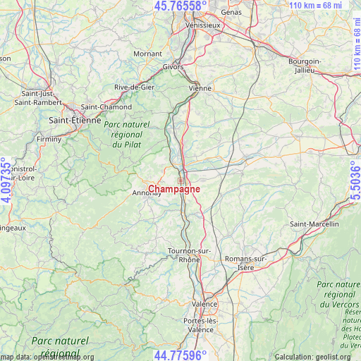
Champagne GPS coordinates[2]
45° 16' 22.548" North, 4° 48' 1.728" East
| Map corner | latitude | longitude |
|---|---|---|
| Upper-left | 45.76558°, | 4.09735° |
| Center: | 45.27293°, | 4.80048° |
| Lower-right: | 44.77596°, | 5.5036° |
| Map W x H: | 110×110 km | = 68.4×68.4mi |
| max Lat: | 51.07786° ⇑76.6% North |
| Champagne: | 45.27293° |
| min Lat: | ⇓23.4% South 41.3874° |
| min Long | Champagne | max Long |
| -5.08615° | 4.80048° | 9.52242° |
| W 75.1%⇐ | ⇒24.9% E |
Elevation
Elevation of Champagne is 140 m = 459 ft, and this is 53.7 m = 176 ft below average elevation for this country.
| Max E: |
2333 m = 7654 ft | 47.8% |
| Avg. | 193.7 m = 635 ft | |
| Champagne | 140 m = 459 ft | |
Min E: |
-1 m = -3 ft | 52.2% |
See also: France elevation on elevation.city.
Geographical zone
Champagne is located in North temperate zone (between Tropic of Cancer and the Arctic Circle). Distance of this North polar circle is 2367.3 km =1471 mi to North.| Distance of | km | miles | from Champagne |
|---|---|---|---|
| North Pole | 4973.2 | 3090.2 | to North |
| Arctic Circle | 2367.3 | 1471 | to North |
| Tropic Cancer | 2428 | 1508.7 | to South |
| Equator | 5033.9 | 3127.9 | to South |


Nearby cities:
15 places around Champagne: (largest is in red/bold)
• Andance
3.6 km =2.2 mi,  181°
181°
• Andancette
2.8 km =1.7 mi,  166°
166°
• Anneyron
6.7 km =4.2 mi,  90°
90°
• Beausemblant
6.7 km =4.2 mi,  158°
158°
• Chanas
5.3 km =3.3 mi,  15°
15°
• Charnas
8.3 km =5.2 mi,  327°
327°
• Davézieux
7.5 km =4.7 mi,  254°
254°
• Félines
7.4 km =4.6 mi,  310°
310°
• Laveyron
7.2 km =4.5 mi, 167°
• Peaugres
5.8 km =3.6 mi,  284°
284°
• Sablons
5.7 km =3.5 mi,  339°
339°
• Saint-Cyr
6 km =3.7 mi, 246°
• Saint-Désirat
2.2 km =1.4 mi,  213°
213°
• Serrières
5.8 km =3.6 mi, 329°
• Talencieux
6 km =3.7 mi,  197°
197°
Sources, notices
• [Note1] Compared only with cities in France existing in our database
• [Src1] Map data: © OpenStreetMap contributors (CC-BY-SA)
• [Src2] Other city data from geonames.org with taken over terms of usage.
• [Src3] Geographical zone / Annual Mean Temperature by Robert A. Rohde @ Wikipedia
