Allonnes geodata
Allonnes (Pays de la Loire) is a populated place; located in France in Europe/Paris (GMT+2) time zone. With population of 11,949 people, there are 808 cities with bigger population in this country. Compared to other cities in France, 58.7% of cities are located further ↓South; 76.6% of cities are located further →East and 82.2% of cities have higher elevation than Allonnes. Note1
Administrative division(s):
- Level 1: Pays de la Loire
- Level 2: Sarthe
- Level 3: Arrondissement du Mans
- Level 4: Allonnes


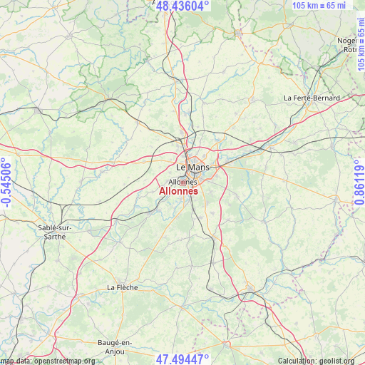
Allonnes GPS coordinates[2]
47° 58' 2.64" North, 0° 9' 29.052" East
| Map corner | latitude | longitude |
|---|---|---|
| Upper-left | 48.43604°, | -0.54506° |
| Center: | 47.9674°, | 0.15807° |
| Lower-right: | 47.49447°, | 0.86119° |
| Map W x H: | 104.7×104.7 km | = 65.1×65.1mi |
| max Lat: | 51.07786° ⇑41.3% North |
| Allonnes: | 47.9674° |
| min Lat: | ⇓58.7% South 41.3874° |
| min Long | Allonnes | max Long |
| -5.08615° | 0.15807° | 9.52242° |
| W 23.4%⇐ | ⇒76.6% E |
Elevation
Elevation of Allonnes is 49 m = 161 ft, and this is 144.7 m = 475 ft below average elevation for this country.
| Max E: |
2333 m = 7654 ft | 82.2% |
| Avg. | 193.7 m = 635 ft | |
| Allonnes | 49 m = 161 ft | |
Min E: |
-1 m = -3 ft | 17.8% |
See also: France elevation on elevation.city.
Geographical zone
Allonnes is located in North temperate zone (between Tropic of Cancer and the Arctic Circle). Distance of this North polar circle is 2067.7 km =1284.8 mi to North.| Distance of | km | miles | from Allonnes |
|---|---|---|---|
| North Pole | 4673.6 | 2904 | to North |
| Arctic Circle | 2067.7 | 1284.8 | to North |
| Tropic Cancer | 2727.6 | 1694.9 | to South |
| Equator | 5333.5 | 3314.1 | to South |


Nearby cities:
15 places around Allonnes: (largest is in red/bold)
• Arnage
5.1 km =3.2 mi,  154°
154°
• Chaufour-Notre-Dame
9 km =5.6 mi,  316°
316°
• Coulaines
7.2 km =4.5 mi,  28°
28°
• Fillé
7.9 km =4.9 mi,  198°
198°
• La Chapelle-Saint-Aubin
7.6 km =4.7 mi,  358°
358°
• Le Mans
5.1 km =3.2 mi,  43°
43°
• Moncé-en-Belin
8.6 km =5.3 mi,  159°
159°
• Pruillé-le-Chétif
4.8 km =3 mi,  307°
307°
• Rouillon
4.6 km =2.9 mi,  338°
338°
• Ruaudin
8.5 km =5.3 mi,  106°
106°
• Saint-Georges-du-Bois
4.3 km =2.7 mi,  277°
277°
• Spay
4.9 km =3 mi,  184°
184°
• Trangé
7.5 km =4.7 mi,  331°
331°
• Voivres-lès-le-Mans
7.7 km =4.8 mi,  236°
236°
• Étival-lès-le-Mans
5.9 km =3.7 mi,  250°
250°
Sources, notices
• [Note1] Compared only with cities in France existing in our database
• [Src1] Map data: © OpenStreetMap contributors (CC-BY-SA)
• [Src2] Other city data from geonames.org with taken over terms of usage.
• [Src3] Geographical zone / Annual Mean Temperature by Robert A. Rohde @ Wikipedia
