Arnage geodata
Arnage (Pays de la Loire) is a populated place; located in France in Europe/Paris (GMT+2) time zone. With population of 5,991 people, there are 1653 cities with bigger population in this country. Compared to other cities in France, 58% of cities are located further ↓South; 76.4% of cities are located further →East and 84.9% of cities have higher elevation than Arnage. Note1
Administrative division(s):
- Level 1: Pays de la Loire
- Level 2: Sarthe
- Level 3: Arrondissement du Mans
- Level 4: Arnage


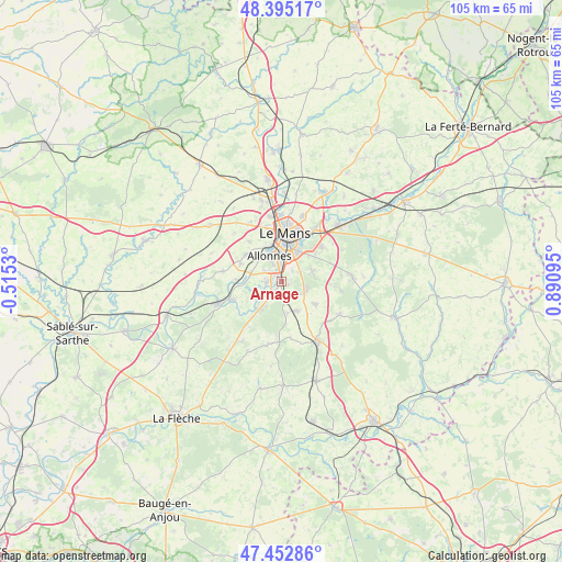
Arnage GPS coordinates[2]
47° 55' 34.176" North, 0° 11' 16.152" East
| Map corner | latitude | longitude |
|---|---|---|
| Upper-left | 48.39517°, | -0.5153° |
| Center: | 47.92616°, | 0.18782° |
| Lower-right: | 47.45286°, | 0.89095° |
| Map W x H: | 104.8×104.8 km | = 65.1×65.1mi |
| max Lat: | 51.07786° ⇑42% North |
| Arnage: | 47.92616° |
| min Lat: | ⇓58% South 41.3874° |
| min Long | Arnage | max Long |
| -5.08615° | 0.18782° | 9.52242° |
| W 23.6%⇐ | ⇒76.4% E |
Elevation
Elevation of Arnage is 42 m = 138 ft, and this is 151.7 m = 498 ft below average elevation for this country.
| Max E: |
2333 m = 7654 ft | 84.9% |
| Avg. | 193.7 m = 635 ft | |
| Arnage | 42 m = 138 ft | |
Min E: |
-1 m = -3 ft | 15.1% |
See also: France elevation on elevation.city.
Geographical zone
Arnage is located in North temperate zone (between Tropic of Cancer and the Arctic Circle). Distance of this North polar circle is 2072.3 km =1287.7 mi to North.| Distance of | km | miles | from Arnage |
|---|---|---|---|
| North Pole | 4678.2 | 2906.9 | to North |
| Arctic Circle | 2072.3 | 1287.7 | to North |
| Tropic Cancer | 2723 | 1692 | to South |
| Equator | 5328.9 | 3311.2 | to South |


Nearby cities:
15 places around Arnage: (largest is in red/bold)
• Allonnes
5.1 km =3.2 mi,  334°
334°
• Fillé
5.5 km =3.4 mi,  238°
238°
• Guécélard
6.9 km =4.3 mi,  218°
218°
• Laigné-en-Belin
6.2 km =3.9 mi,  151°
151°
• Le Mans
8.3 km =5.2 mi,  8°
8°
• Moncé-en-Belin
3.6 km =2.2 mi,  167°
167°
• Mulsanne
4.9 km =3 mi,  109°
109°
• Roézé-sur-Sarthe
9.6 km =6 mi,  249°
249°
• Ruaudin
6.3 km =3.9 mi,  70°
70°
• Saint-Georges-du-Bois
8.3 km =5.2 mi,  308°
308°
• Saint-Gervais-en-Belin
5.9 km =3.7 mi,  157°
157°
• Spay
2.6 km =1.6 mi,  264°
264°
• Teloché
7.5 km =4.7 mi,  124°
124°
• Voivres-lès-le-Mans
8.6 km =5.3 mi,  272°
272°
• Étival-lès-le-Mans
8.2 km =5.1 mi,  288°
288°
Sources, notices
• [Note1] Compared only with cities in France existing in our database
• [Src1] Map data: © OpenStreetMap contributors (CC-BY-SA)
• [Src2] Other city data from geonames.org with taken over terms of usage.
• [Src3] Geographical zone / Annual Mean Temperature by Robert A. Rohde @ Wikipedia
