Ruaudin geodata
Ruaudin (Pays de la Loire) is a populated place; located in France in Europe/Paris (GMT+2) time zone. With population of 2,994 people, there are 3258 cities with bigger population in this country. Compared to other cities in France, 58.3% of cities are located further ↓South; 75.6% of cities are located further →East and 79.4% of cities have higher elevation than Ruaudin. Note1
Administrative division(s):
- Level 1: Pays de la Loire
- Level 2: Sarthe
- Level 3: Arrondissement du Mans
- Level 4: Ruaudin


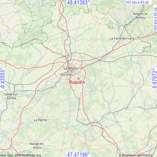
Ruaudin GPS coordinates[2]
47° 56' 42.324" North, 0° 16' 3.36" East
| Map corner | latitude | longitude |
|---|---|---|
| Upper-left | 48.41393°, | -0.43553° |
| Center: | 47.94509°, | 0.2676° |
| Lower-right: | 47.47196°, | 0.97072° |
| Map W x H: | 104.7×104.7 km | = 65.1×65.1mi |
| max Lat: | 51.07786° ⇑41.7% North |
| Ruaudin: | 47.94509° |
| min Lat: | ⇓58.3% South 41.3874° |
| min Long | Ruaudin | max Long |
| -5.08615° | 0.2676° | 9.52242° |
| W 24.4%⇐ | ⇒75.6% E |
Elevation
Elevation of Ruaudin is 56 m = 184 ft, and this is 137.7 m = 452 ft below average elevation for this country.
| Max E: |
2333 m = 7654 ft | 79.4% |
| Avg. | 193.7 m = 635 ft | |
| Ruaudin | 56 m = 184 ft | |
Min E: |
-1 m = -3 ft | 20.6% |
See also: France elevation on elevation.city.
Geographical zone
Ruaudin is located in North temperate zone (between Tropic of Cancer and the Arctic Circle). Distance of this North polar circle is 2070.2 km =1286.4 mi to North.| Distance of | km | miles | from Ruaudin |
|---|---|---|---|
| North Pole | 4676.1 | 2905.6 | to North |
| Arctic Circle | 2070.2 | 1286.4 | to North |
| Tropic Cancer | 2725.1 | 1693.3 | to South |
| Equator | 5331 | 3312.5 | to South |


Nearby cities:
15 places around Ruaudin: (largest is in red/bold)
• Allonnes
8.5 km =5.3 mi,  286°
286°
• Arnage
6.3 km =3.9 mi,  250°
250°
• Brette-les-Pins
6.4 km =4 mi,  126°
126°
• Champagné
9.8 km =6.1 mi,  28°
28°
• Changé
4.6 km =2.9 mi,  14°
14°
• Coulaines
10 km =6.2 mi,  331°
331°
• Laigné-en-Belin
8.1 km =5 mi,  201°
201°
• Le Mans
7.7 km =4.8 mi,  322°
322°
• Moncé-en-Belin
7.7 km =4.8 mi,  222°
222°
• Mulsanne
4 km =2.5 mi, 200°
• Saint-Gervais-en-Belin
8.4 km =5.2 mi,  206°
206°
• Saint-Mars-d’Outillé
9.6 km =6 mi,  149°
149°
• Sargé-lès-le-Mans
10.1 km =6.3 mi,  345°
345°
• Spay
8.9 km =5.5 mi, 254°
• Teloché
6.3 km =3.9 mi,  177°
177°
Sources, notices
• [Note1] Compared only with cities in France existing in our database
• [Src1] Map data: © OpenStreetMap contributors (CC-BY-SA)
• [Src2] Other city data from geonames.org with taken over terms of usage.
• [Src3] Geographical zone / Annual Mean Temperature by Robert A. Rohde @ Wikipedia
