Allègre-les-Fumades geodata
Allègre-les-Fumades (Occitanie) is a populated place; located in France in Europe/Paris (GMT+2) time zone. With population of 712 people, there are 11628 cities with bigger population in this country. Compared to other cities in France, 85.5% of cities are located further ↑North; 70.2% of cities are located further ←West and 51.4% of cities have higher elevation than Allègre-les-Fumades. Note1
Administrative division(s):
- Level 1: Occitanie
- Level 2: Gard
- Level 3: Arrondissement d’Alès
- Level 4: Allègre-les-Fumades


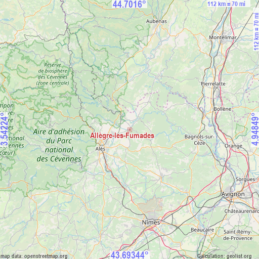
Allègre-les-Fumades GPS coordinates[2]
44° 11' 58.848" North, 4° 14' 43.296" East
| Map corner | latitude | longitude |
|---|---|---|
| Upper-left | 44.7016°, | 3.54224° |
| Center: | 44.19968°, | 4.24536° |
| Lower-right: | 43.69344°, | 4.94849° |
| Map W x H: | 112.1×112.1 km | = 69.7×69.7mi |
| max Lat: | 51.07786° ⇑85.5% North |
| Allègre-les-Fumades: | 44.19968° |
| min Lat: | ⇓14.5% South 41.3874° |
| min Long | Allègre-les-Fu | max Long |
| -5.08615° | 4.24536° | 9.52242° |
| W 70.2%⇐ | ⇒29.8% E |
Elevation
Elevation of Allègre-les-Fumades is 127 m = 417 ft, and this is 66.7 m = 219 ft below average elevation for this country.
| Max E: |
2333 m = 7654 ft | 51.4% |
| Avg. | 193.7 m = 635 ft | |
| Allègre-les-Fumades | 127 m = 417 ft | |
Min E: |
-1 m = -3 ft | 48.6% |
See also: France elevation on elevation.city.
Geographical zone
Allègre-les-Fumades is located in North temperate zone (between Tropic of Cancer and the Arctic Circle). Distance of this Northern Tropic circle is 2308.6 km =1434.5 mi to South.| Distance of | km | miles | from Allègre-les-Fumades |
|---|---|---|---|
| North Pole | 5092.5 | 3164.3 | to North |
| Arctic Circle | 2486.6 | 1545.1 | to North |
| Tropic Cancer | 2308.6 | 1434.5 | to South |
| Equator | 4914.5 | 3053.7 | to South |


Nearby cities:
15 places around Allègre-les-Fumades: (largest is in red/bold)
• Brouzet-lès-Alès
7.1 km =4.4 mi,  179°
179°
• Les Mages
6.9 km =4.3 mi,  298°
298°
• Meyrannes
10 km =6.2 mi,  322°
322°
• Molières-sur-Cèze
9.6 km =6 mi,  314°
314°
• Mons
11.1 km =6.9 mi,  211°
211°
• Rousson
7.8 km =4.8 mi,  263°
263°
• Saint-Ambroix
7.6 km =4.7 mi,  330°
330°
• Saint-Jean-de-Maruéjols-et-Avéjan
7.4 km =4.6 mi,  31°
31°
• Saint-Jean-de-Valériscle
8.6 km =5.3 mi,  293°
293°
• Saint-Julien-de-Cassagnas
3.9 km =2.4 mi, 286°
• Saint-Julien-les-Rosiers
11.3 km =7 mi, 255°
• Saint-Privat-des-Vieux
11.1 km =6.9 mi,  236°
236°
• Saint-Sauveur-de-Cruzières
11.1 km =6.9 mi,  3°
3°
• Saint-Victor-de-Malcap
6 km =3.7 mi,  341°
341°
• Salindres
7.5 km =4.7 mi,  245°
245°
Sources, notices
• [Note1] Compared only with cities in France existing in our database
• [Src1] Map data: © OpenStreetMap contributors (CC-BY-SA)
• [Src2] Other city data from geonames.org with taken over terms of usage.
• [Src3] Geographical zone / Annual Mean Temperature by Robert A. Rohde @ Wikipedia
